Menominee Pier Light
 | |
 | |
| Location | Menominee, Michigan |
|---|---|
| Coordinates | 45°05′50.2″N 85°35′9.6″W / 45.097278°N 85.586000°WCoordinates: 45°05′50.2″N 85°35′9.6″W / 45.097278°N 85.586000°W[1] |
| Year first lit | 1927 |
| Automated | 1972 |
| Foundation | Concrete pier |
| Construction | Cast iron |
| Tower shape | Octagonal |
| Markings / pattern | red Daymark with black lantern and white base |
| Height | 34 feet (10 m) |
| Focal height | 46 feet (14 m) |
| Original lens | Fourth Order Fresnel lens |
| Current lens | 12-inch (300 mm) Tideland Signal ML-300 acrylic |
| Range | 9 nautical miles (17 km; 10 mi)[1] |
| Characteristic | Fl R 4s |
| ARLHS number | USA-490 |
| USCG number |
7-21935 |
|
Menominee Pierhead Light Station | |
| Nearest city | Menominee, Michigan |
| Area | less than one acre |
| Built | 1927 |
| MPS | Light Stations of the United States MPS |
| NRHP reference # | 05000738[2] |
| Added to NRHP | July 27, 2005 |
| Heritage |
place listed on the National Register of Historic Places |
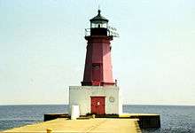
The Menominee North Pier lighthouse is located in the harbor of Menominee, Michigan. The station was first lit in 1877. The current structure and its still operational light was lit in 1927, and automated in 1972.[3] It is also sometimes called the "Menominee (Marinette) North Pierhead Light".[4]
The foundation is a concrete pier. The 34-foot (10 m) tall octagonal cast iron building is marked in a distinctive red, with a black lantern and white base. A Fourth Order Fresnel lens was originally installed, but was replaced with a modern 12-inch (300 mm) acrylic optic lens.[5] The original lens is now at Sand Point Light in Escanaba, Michigan.[6] The focal plane is 46 feet (14 m).[7]
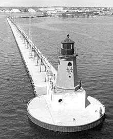
The building originally had a diaphone fog signal structure attached, and it was later removed. The iron catwalk was removed in 1972 when the light was automated.[8]
This light is paired with a large rear range light.[9] That is denominated the Menominee (Marinette) North Pier light, and is also an active aid to navigation. Its focal plane 59 feet (18 m), and its characteristic is a continuous red light. The tower is a 50-foot (15 m)square pyramidal steel skeletal tower with gallery. It is painted red, and located on the Menominee North Pier about 600 feet (180 m) from the pierhead light.[10] It may be accessed by walking the pier. The site is open, but the tower is closed. U.S. Coast Guard. USCG 7-21940.[4]
References
- 1 2 Light List, Volume VII, Great Lakes (PDF). Light List. United States Coast Guard.
- ↑ National Park Service (2010-07-09). "National Register Information System". National Register of Historic Places. National Park Service.
- ↑ "Historic Light Station Information and Photography: Michigan". United States Coast Guard Historian's Office.
- 1 2 Rowlett, Russ. "Lighthouses of the United States: Michigan's Eastern Upper Peninsula". The Lighthouse Directory. University of North Carolina at Chapel Hill.
- ↑ Terry Pepper, Seeing the Light, 300 mm. acrylic optic lens.
- ↑ Wobser, David, Menoninee Pier Light at Boatnerd.com.
- ↑ National Park Service, Maritime Heritage Inventory of Historic Lights, Menoninee Pier Light.
- ↑ Terry Pepper, Seeing the Light, Menoninee Pier Light.
- ↑ Lighthoues R US, Menoninee Pier Lights.
- ↑ See the photo, National Park Service, Maritime Heritage Inventory of Historic Lights, Menoninee North Pier Light.
External links

- Detroit News, Interactive map on Michigan lighthouses.
- Interactive map of Lights in Northern Lake Michigan, mapped by Google.
- Lighthouse Central, Menominee North Pier Light, The Ultimate Guide to Upper Michigan Lighthouses by Jerry Roach.. (Publisher: Bugs Publishing LLC - 2007). ISBN 978-0-9747977-2-4.
- Lighthouse depot, Menoninee Pier Light.
- Lighthouse friends, Menoninee North Pier Light.
- Michigan Lighthouse Conservancy, Menoninee North Pier Light.
- Map of Michigan Lighthouse in PDF Format.
- Terry Pepper, Seeing the Light, Menoninee Pier Light.
- National Park Service Maritime Heritage Inventory of Historic Lights, Menoninee North Pier Light.
- Map of lighthouses in western Lake Michigan.
- Light List, Volume VII, Great Lakes (PDF). Light List. United States Coast Guard.
| Topics | |
|---|---|
| Lists by states |
|
| Lists by insular areas | |
| Lists by associated states | |
| Other areas | |
| |