Meleti
| Meleti Melét (Lombard) | ||
|---|---|---|
| Comune | ||
| Comune di Meleti | ||
 | ||
| ||
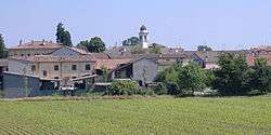
 Meleti Location of Meleti in Italy | ||
| Coordinates: 45°10′N 9°51′E / 45.167°N 9.850°E | ||
| Country | Italy | |
| Region | Lombardy | |
| Province | Lodi (LO) | |
| Government | ||
| • Mayor | Mario Raffaele Rocca | |
| Area | ||
| • Total | 7.39 km2 (2.85 sq mi) | |
| Elevation | 40 m (130 ft) | |
| Population (31 October 2017)[1] | ||
| • Total | 446 | |
| • Density | 60/km2 (160/sq mi) | |
| Demonym(s) | Meletesi | |
| Time zone | UTC+1 (CET) | |
| • Summer (DST) | UTC+2 (CEST) | |
| Postal code | 26843 | |
| Dialing code | 0377 | |
| Website | Official website | |
Meleti (Lodigiano: Melét; locally Mlìd) is a comune (municipality) in the Province of Lodi in the Italian region Lombardy, located about 60 kilometres (37 mi) southeast of Milan and about 30 kilometres (19 mi) southeast of Lodi.
| Wikimedia Commons has media related to Meleti. |
Meleti borders the following municipalities: Crotta d'Adda, Cornovecchio, Maccastorna, Castelnuovo Bocca d'Adda, Caselle Landi.
References

This article is issued from
Wikipedia.
The text is licensed under Creative Commons - Attribution - Sharealike.
Additional terms may apply for the media files.