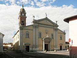
Livraga
| Livraga | |
|---|---|
| Comune | |
| Comune di Livraga | |
 | |
 | |
 Livraga Location of Livraga in Italy | |
| Coordinates: 45°12′N 9°34′E / 45.200°N 9.567°ECoordinates: 45°12′N 9°34′E / 45.200°N 9.567°E | |
| Country | Italy |
| Region | Lombardy |
| Province | Province of Lodi (LO) |
| Area | |
| • Total | 12.2 km2 (4.7 sq mi) |
| Population (Dec. 2004) | |
| • Total | 2,589 |
| • Density | 210/km2 (550/sq mi) |
| Time zone | UTC+1 (CET) |
| • Summer (DST) | UTC+2 (CEST) |
| Postal code | 26814 |
| Dialing code | 0377 |
| Website | Official website |
Livraga is a comune (municipality) in the Province of Lodi in the Italian region Lombardy, located about 45 kilometres (28 mi) southeast of Milan and about 14 kilometres (9 mi) southeast of Lodi. As of 31 December 2004, it had a population of 2,589 and an area of 12.2 square kilometres (4.7 sq mi).[1]
Livraga borders the following municipalities: Brembio, Borghetto Lodigiano, San Colombano al Lambro, Ospedaletto Lodigiano, Orio Litta.
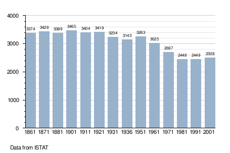
Demographic evolution
References
External links

This article is issued from
Wikipedia.
The text is licensed under Creative Commons - Attribution - Sharealike.
Additional terms may apply for the media files.