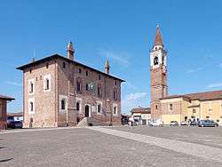
Borghetto Lodigiano
| Borghetto Lodigiano | ||
|---|---|---|
| Comune | ||
| Comune di Borghetto Lodigiano | ||
 | ||
| ||
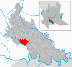 | ||
 Borghetto Lodigiano Location of Borghetto Lodigiano in Italy | ||
| Coordinates: 45°12′N 9°30′E / 45.200°N 9.500°ECoordinates: 45°12′N 9°30′E / 45.200°N 9.500°E | ||
| Country | Italy | |
| Region | Lombardy | |
| Province | Lodi (LO) | |
| Frazioni | Casoni, Fornaci, Panigada, Pantiara, Proprio, Vigarolo | |
| Government | ||
| • Mayor | Giovanna Gargioni | |
| Area | ||
| • Total | 23.6 km2 (9.1 sq mi) | |
| Elevation | 68 m (223 ft) | |
| Population (30 September 2017)[1] | ||
| • Total | 4,280 | |
| • Density | 180/km2 (470/sq mi) | |
| Demonym(s) | Borghettini | |
| Time zone | UTC+1 (CET) | |
| • Summer (DST) | UTC+2 (CEST) | |
| Postal code | 26812 | |
| Dialing code | 0371 | |
| Website | Official website | |
Borghetto Lodigiano (Lodigiano: Burghét) is a comune (municipality) in the Province of Lodi in the Italian region Lombardy, located about 40 kilometres (25 mi) southeast of Milan and about 11 kilometres (7 mi) south of Lodi. It is located on the left slope of the Lambro river.
Borghetto Lodigiano borders the following municipalities: Ossago Lodigiano, Villanova del Sillaro, Brembio, Graffignana, Livraga, San Colombano al Lambro. The economy is mostly based on agriculture and on production of aluminium.
References
External links

This article is issued from
Wikipedia.
The text is licensed under Creative Commons - Attribution - Sharealike.
Additional terms may apply for the media files.