Mdoukha
| Mdoukha مدوخا | |
|---|---|
| Village | |
| Country |
|
| Governorate | Beqaa |
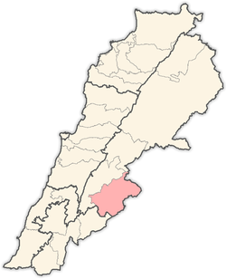
| District | Rashaya |
| Area | |
| • Total | 5.86 sq mi (15.18 km2) |
| Elevation | 3,261 ft (994 m) |
 Shown within Lebanon | |
| Alternative name | Jebel Kassir |
|---|---|
| Location | 72 kilometres (45 mi) east of Beirut |
| Region | Rashaya |
| Coordinates | 33°36′23″N 35°52′37″E / 33.606389°N 35.876944°E |
| History | |
| Cultures | Roman |
| Site notes | |
| Condition | Ruins |
| Public access | Yes |
| Website | Mdoukha Village Website |
Mdoukha (Arabic: مدوخا) is a village and municipality situated 72 kilometres (45 mi) east of Beirut in the Rashaya District, Beqaa Governorate, Lebanon.[1][2] The village's population is Sunni. A significant majority of the population are also Lebanese Canadians, of which 60% live in London, Ontario. [3]
Mdoukha is one of the most beautiful villages in the Rachaya District of Lebanon. It lies in the Beqaa Valley, about 15 Km northwest of Mount Hermon, 70 Km from the capital Beirut and lies 1150 m above sea level. Villages that surround Mdoukha are Kherbet Rouha , Ayn Araab, , Al-Berih, Bakka , Al-Rafid and Kfardenis.
Mdoukha has a few natural and historic destinations. For example, on top of Mdoukha's tallest mountain, there is a castle that dates back 8000 years ago; it is said that there is gold under the castle. Also there is place where endless ground water is spewing out and it is safe and clean to drink. Villages that surround Mdoukha are: Kherbet Rouha, Ayn Araab, Al-Berih, Bekka, Al-Rafid and Kafardenis. Mdoukha's population is approximately 3300 people. With modern architecture and the building of new homes, Mdoukha has never lost its historical image represented by the old houses. Mdoukha's family names include: Abdo , Abdulhamid , Abdulkarim , Assaf, Birani , Borhot , Chahbar , Chams , Hage , Hammoud , Jambein , Meddoui , Merhi , Moussa, Elnazali , Omar , Soufan , Zabian and Youssef .
External links
- video of Mdoukha on YouTube
- Mdoukha Stargazing forecast
- Mdoukha on Localiban
- Photos of Roman temples in the Rashaya area on the American University of Beirut website
- Roman Temples on discoverlebanon.com
- Jebel Kassir Roman temple on www.middleeast.com
- Mdoukha on geographic.org
- Bakka municipality on Wikimapia
- Photo of Jebel Kassir Roman Temple on the American University of Beirut website
- Photo of Jebel Kassir Roman Temple on the American University of Beirut website
- Photo of Jebel Kassir Roman Temple on the American University of Beirut website
Capital: Rashaya | ||
| Towns and villages |
|  |
- ↑ George Taylor (1971). The Roman temples of Lebanon: a pictorial guide. Les temples romains au Liban; guide illustré. Dar el-Machreq Publishers. Retrieved 23 September 2012.
- ↑ Université Saint-Joseph (Beirut, Lebanon) (1968). Mélanges de l'Université Saint-Joseph. Imprimerie Catholique. Retrieved 24 September 2012.
- ↑ "The Monthly - issue 91" (PDF). localiban. p. 7. Archived from the original (PDF) on 4 March 2016. Retrieved 25 December 2015.