Al-Rafid, Lebanon
| Al-Rafid الرفيد Al-Rafeed | |
|---|---|
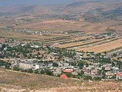 View of the northeastern part of al-Rafid | |
 Al-Rafid Location in Lebanon | |
| Coordinates: 33°34′16″N 35°49′1″E / 33.57111°N 35.81694°ECoordinates: 33°34′16″N 35°49′1″E / 33.57111°N 35.81694°E | |
| Lebanon | |
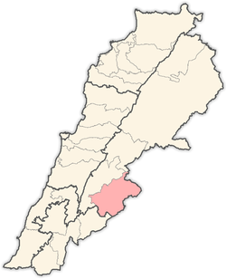
| Governorate | Beqaa |
| District | Rashaya |
| Population | |
| • Total | 3,000 |
Al-Rafid (Arabic: الرفيد) is a village in the Rashaya District, in the southeastern area of the Beqaa Governorate in Lebanon. Its population is estimated to be 3,000. Its inhabitants are predominantly Sunni Muslims. The village has two mosques, two schools, two pharmacies, and a telecommunications facility.
Overview
The oldest part of the village lies halfway up Mount Baaloul (Jabal Baaloul) on the eastern slope. It is widely accepted by the inhabitants of the town that the town was originally located on the top of the mountain but was re-located after a civil strife had subsided over 400 years ago. Neighboring localities include Beere, Muhaydhi, Khirbet-Rouha, and Mdouckha. The town is located about 80 km (50 mi) from Beirut and 40 km (25 mi) from Damascus, Syria. From Al-Rafid, Jabal -Al-Sheikh (Mount Hermon) can be seen with its majestic snow-capped peak.
The village was occupied first by PLO forces in the late 1970s, then by Israeli forces in the early 1980s. Before Israel's invasion, the town suffered from Israeli warplane attacks. In one incident, the school was bombed, killing a mother and her four children. Israel said that the school was being used as a base for PLO forces.
External links
- Rafid, Localiban
Capital: Rashaya | ||
| Towns and villages |
|  |