McIntosh, Alabama
| McIntosh, Alabama | |
|---|---|
| Town | |
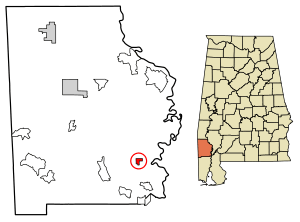 Location of McIntosh in Washington County, Alabama. | |
| Coordinates: 31°15′58″N 88°1′53″W / 31.26611°N 88.03139°W | |
| Country | United States |
| State | Alabama |
| County | Washington |
| Area[1] | |
| • Total | 1.00 sq mi (2.58 km2) |
| • Land | 1.00 sq mi (2.58 km2) |
| • Water | 0.00 sq mi (0.00 km2) |
| Elevation | 49 ft (15 m) |
| Population (2010) | |
| • Total | 238 |
| • Estimate (2017)[2] | 223 |
| • Density | 223.90/sq mi (86.44/km2) |
| Time zone | UTC-6 (Central Time (CT)) |
| • Summer (DST) | UTC-5 (CDT) |
| ZIP code | 36553 |
| Area code(s) | 251 |
| FIPS code | 01-45472 |
| GNIS feature ID | 0152280 |
| Website | http://mcintoshalabama.com/ |
McIntosh is a town located in Washington County, Alabama, United States along U.S. Route 43. It is 12 1⁄2 miles (20.1 km) south of Wagarville and 44 miles (71 km) north of Mobile. It was named for William McIntosh, a prominent Creek chief of the nineteenth century. The town was incorporated on April 7, 1970.[3] The population as of the 2010 U.S. Census was 238, down from 244 in 2000.
The town and county have a high proportion of residents who are members of the MOWA Band of Choctaw Indians, a state-recognized tribe of people of the Muskogean-speaking language family. It has one site, Andrews Chapel, listed on the National Register of Historic Places.[4]
McIntosh is near the site of Aaron Burr's arrest in 1807 while the area was part of the Mississippi Territory. He was captured by U.S. Army Lt. Edmund P. Gaines in the town of Wakefield, a few miles to the north, and then confined to Fort Stoddert. A historic marker has been placed to document this event.[5]
Geography
McIntosh is located at 31°15'58" North, 88°1'53" West (31.265979, -88.031473).[6] According to the U.S. Census Bureau, the town has a total area of 1.0 square mile (2.6 km2), all land.
Demographics
| Historical population | |||
|---|---|---|---|
| Census | Pop. | %± | |
| 1970 | 297 | — | |
| 1980 | 319 | 7.4% | |
| 1990 | 250 | −21.6% | |
| 2000 | 244 | −2.4% | |
| 2010 | 238 | −2.5% | |
| Est. 2017 | 223 | [2] | −6.3% |
| U.S. Decennial Census[7] 2013 Estimate[8] | |||
As of the census of 2000,[9] there were 244 people, 94 households and 62 families in the town. The population density was 243.9 people per square mile (94.2/km2). There were 98 housing units at an average density of 98.0 per square mile (37.8/km2). The racial makeup of the town was 55.23% Native American, 43.03% Black or African American, 1.33% White and 0.41% from two or more races. 0,41% of the population were Hispanic or Latino of any race.
There are 94 households out of which 36.2% had children under the age of 18 living with them, 47.9% were married couples living together, 18.1% had a female householder with no husband present, and 33.0% were non-families. 30.9% of all households were made up of individuals and 11.7% had someone living alone who is 65 years of age or older. The average household size was 2.60 and the average family size is 3.27.
In the town, the population is spread out with 29.5% under the age of 18, 6.6% from 18 to 24, 24.6% from 25 to 44, 25.0% from 45 to 64, and 14.3% who are 65 years of age or older. The median age was 35 years. For every 100 females, there were 83.5 males. For every 100 females age 18 and over, there were 72.0 males.
The median income for a household in the town was $28,214, and the median income for a family was $39,167. Males had a median income of $31,429 versus $22,750 for females. The per capita income for the town was $14,023. 13.5% of the population and 10.0% of families were below the poverty line. Out of the total population, 22.2% of those under the age of 18 and 9.1% of those 65 and older were living below the poverty line.
Notable person
- Greg Wells, former Major League Baseball player
References
- ↑ "2017 U.S. Gazetteer Files". United States Census Bureau. Retrieved Jul 7, 2018.
- 1 2 "Population and Housing Unit Estimates". Retrieved March 24, 2018.
- ↑ http://mcintoshal.com/
- ↑ National Park Service (2009-03-13). "National Register Information System". National Register of Historic Places. National Park Service.
- ↑ "Alabama Historical Marker Program-Washington County". Archived from the original on 2013-02-22. Retrieved 2012-12-30.
- ↑ "US Gazetteer files: 2010, 2000, and 1990". United States Census Bureau. 2011-02-12. Retrieved 2011-04-23.
- ↑ "U.S. Decennial Census". Census.gov. Archived from the original on May 12, 2015. Retrieved June 6, 2013.
- ↑ "Annual Estimates of the Resident Population: April 1, 2010 to July 1, 2013". Retrieved June 3, 2014.
- ↑ "American FactFinder". United States Census Bureau. Archived from the original on September 11, 2013. Retrieved 2008-01-31.
External links
- PowerSouth Energy Cooperative's compressed air energy storage power plant (archived)
- Tate & Lyle Sucralose plant EPA Report for 2003
- "95 workers in McIntosh vote to join AFL-CIO"
Coordinates: 31°15′58″N 88°01′53″W / 31.265979°N 88.031473°W
Municipalities and communities of Washington County, Alabama, United States | ||
|---|---|---|
| Towns |  | |
| CDPs | ||
| Unincorporated communities | ||
| Ghost towns | ||
| Footnotes | ‡This populated place also has portions in an adjacent county or counties | |