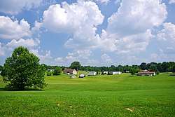
McHenry, Kentucky
| McHenry, Kentucky | |
|---|---|
| City | |
 McHenry | |
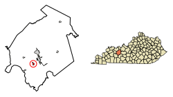 Location of McHenry in Ohio County, Kentucky. | |
| Coordinates: 37°22′42″N 86°55′21″W / 37.37833°N 86.92250°WCoordinates: 37°22′42″N 86°55′21″W / 37.37833°N 86.92250°W | |
| Country | United States |
| State | Kentucky |
| County | Ohio |
| Incorporated | 1880[1] |
| Named for | Rep. Henry D. McHenry |
| Area | |
| • Total | 0.7 sq mi (1.8 km2) |
| • Land | 0.7 sq mi (1.8 km2) |
| • Water | 0.0 sq mi (0.0 km2) |
| Elevation | 420 ft (128 m) |
| Population (2010) | |
| • Total | 388 |
| • Estimate (2016)[2] | 395 |
| • Density | 599.9/sq mi (231.6/km2) |
| Time zone | UTC-6 (Central (CST)) |
| • Summer (DST) | UTC-5 (CDT) |
| ZIP code | 42354 |
| Area code(s) | 270 |
| FIPS code | 21-49098 |
| GNIS feature ID | 0497881 |
McHenry is a home rule-class city in Ohio County, Kentucky, in the United States. The population was 417 at the time of the year 2000 U.S. census.
History
Originally called Hamelton, the town was renamed in 1874 to honor Congressman Henry D. McHenry.[3]
Geography
McHenry is located at 37°22′42″N 86°55′21″W / 37.37833°N 86.92250°W (37.378399, -86.922391).[4] The city is situated along U.S. Route 62 southwest of Beaver Dam and northeast of Central City. According to the United States Census Bureau, the city has a total area of 0.7 square miles (1.8 km2), all land.
Demographics
| Historical population | |||
|---|---|---|---|
| Census | Pop. | %± | |
| 1880 | 124 | — | |
| 1890 | 463 | 273.4% | |
| 1900 | 550 | 18.8% | |
| 1910 | 580 | 5.5% | |
| 1920 | 439 | −24.3% | |
| 1930 | 608 | 38.5% | |
| 1940 | 722 | 18.8% | |
| 1950 | 511 | −29.2% | |
| 1960 | 446 | −12.7% | |
| 1970 | 420 | −5.8% | |
| 1980 | 582 | 38.6% | |
| 1990 | 414 | −28.9% | |
| 2000 | 417 | 0.7% | |
| 2010 | 388 | −7.0% | |
| Est. 2016 | 395 | [2] | 1.8% |
| U.S. Decennial Census[5] | |||
As of the census[6] of 2000, there were 417 people, 161 households, and 118 families residing in the city. The population density was 599.9 people per square mile (230.0/km²). There were 186 housing units at an average density of 267.6 per square mile (102.6/km²). The racial makeup of the city was 100.00% White.
There were 161 households out of which 32.3% had children under the age of 18 living with them, 53.4% were married couples living together, 13.7% had a female householder with no husband present, and 26.1% were non-families. 19.9% of all households were made up of individuals and 6.8% had someone living alone who was 65 years of age or older. The average household size was 2.59 and the average family size was 3.00.
In the city, the population was spread out with 27.6% under the age of 18, 7.9% from 18 to 24, 30.9% from 25 to 44, 20.4% from 45 to 64, and 13.2% who were 65 years of age or older. The median age was 35 years. For every 100 females, there were 93.1 males. For every 100 females age 18 and over, there were 96.1 males.
The median income for a household in the city was $23,000, and the median income for a family was $28,750. Males had a median income of $28,750 versus $15,104 for females. The per capita income for the city was $12,847. About 20.2% of families and 24.1% of the population were below the poverty line, including 33.0% of those under age 18 and 25.4% of those age 65 or over.
References
- ↑ Commonwealth of Kentucky. Office of the Secretary of State. Land Office. "McHenry, Kentucky". Accessed 26 August 2013.
- 1 2 "Population and Housing Unit Estimates". Retrieved June 9, 2017.
- ↑ "Dictionary of Places: McHenry". Encyclopedia of Kentucky. New York, New York: Somerset Publishers. 1987. ISBN 0-403-09981-1.
- ↑ "US Gazetteer files: 2010, 2000, and 1990". United States Census Bureau. 2011-02-12. Retrieved 2011-04-23.
- ↑ "Census of Population and Housing". Census.gov. Archived from the original on May 12, 2015. Retrieved June 4, 2015.
- ↑ "American FactFinder". United States Census Bureau. Archived from the original on September 11, 2013. Retrieved 2008-01-31.
External links

Municipalities and communities of Ohio County, Kentucky, United States | ||
|---|---|---|
| Cities | 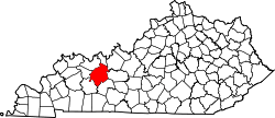 | |
| CDP | ||
| Other unincorporated communities | ||