Mbandaka
| Mbandaka Coquilhatville | |
|---|---|
| Ville de Mbandaka | |
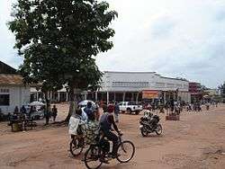 Commercial center of Mbandaka, 2008 | |
 Mbandaka Location in the Democratic Republic of the Congo | |
| Coordinates: 0°02′52″N 18°15′21″E / 0.04778°N 18.25583°ECoordinates: 0°02′52″N 18°15′21″E / 0.04778°N 18.25583°E | |
| Country | Democratic Republic of the Congo |
| Province | Équateur Province |
| Founded | 1883 |
| Area | |
| • Total | 460 km2 (180 sq mi) |
| Elevation | 370 m (1,210 ft) |
| Population (2012)[1] | |
| • Total | 345,663 |
| • Density | 750/km2 (1,900/sq mi) |
| Time zone | UTC+1 (WAT) |
Mbandaka, pronounced mba ˈnda ka and formerly known as Coquilhatville in French or Coquilhatstad in Flemish, is a city on the Congo River in the Democratic Republic of Congo lying near the confluence of the Congo and Ruki Rivers. It is the capital of Équateur Province.
The headquarters of the Fourth Naval Region of the Navy of the Democratic Republic of the Congo are located in Mbandaka.
Geography
Mbandaka lies on the east bank of the Congo River below the mouth of the Tshuapa River, a tributary of the Congo. South of the Ngiri Reserve, a large area of swamp forest on the opposite bank of the Congo, it lies at the center of the Tumba-Ngiri-Maindombe Ramsar wetland.[2]
Mbandaka is the capital of Equateur province, and located only a few miles from the equator. It is home to Mbandaka airport and is linked by riverboat to Kinshasa and Boende. The city's population was approximately 729,257 (2004). The city is home to almost 1.2 million people in 2018.
It lies in a busy travel corridor upstream from the capital, Kinshasa, a city of about 10 million that is an hour's plane ride away or a four- to seven-day trip by river barge.
Mbandaka is largely populated by people of the Mongo ethnic group although people from many different tribes and regions live in the city. The main languages spoken in Mbandaka are Lingala, French, and Mongo.
Years of war and neglect have taken a heavy toll on the city infrastructure, leaving no electricity or running water in large sectors of the city. Most of the streets and avenues of the city are dirt roads.

History
Mbandaka was founded in 1883 by Henry Morton Stanley with the name of "Équateurville". The town hall is about 4 kilometres (2.5 mi) north of the equator. Mbandaka is one of the closest to the equator of any substantial city in the world. Stanley placed a large "Equator Stone" near the riverbank south of the city to mark the point where he believed the equator crossed the river. It remains there today. Due to its symbolic location close to the equator and the Congo River, there were early plans to locate the capital of the Congo Free State in Mbandaka, but they never came off the drawing board. These plans included infrastructure for an estimated population of 100,000 people, a train station, a Catholic cathedral, a governor's residence, and a palace for future visits of Leopold II of Belgium.[4]
In 1886, at the beginning of colonial rule, the Belgians changed the city's name to "Coquilhatville" naming it after Camille-Aimé Coquilhat.
In 1938, work began on a bridge over the Congo River connecting Mbandaka with the French Congo. Work was abandoned at the outbreak of World War II, and only the foundations of the bridge pillars remain. In the 1930s the Belgian colonial administration began several projects, including factories and a new city hall. The city hall was completed in 1947 after World War II and at that time, with a height of 39 meters, was the tallest building in the Belgian Congo.
On top of the city hall stood a statue of Leopold II. The city hall was destroyed by a fire in 1963.[5]
In 1966, the city's name was changed, this time by the new independent government, to "Mbandaka" to honor a prominent local leader.
Massacre of Hutus
Hundreds of people (mainly Hutu refugees, women, and children) were massacred on May 13, 1997 near the end of the First Congo War.[6][7] Congolese soldiers said the order came from Col. Wilson, head of a brigade of Kabila's troops, and Col. Richard, the brigade's operations chief, both Rwandans. A Congolese, Gen. Gaston Muyango, held the title of military commander but had no real power, they said.[8]
Ebola outbreak
On 16 May 2018, a case of Ebola occurred in the city, spreading there from an outbreak in the countryside.[9][10]
Notable places
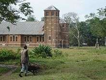
Catholic Mission station and Central African history research centre of Bamanya
A large research centre for Central African history, originally set up by Fathers Gustaaf Hulstaert (1900–1990) and Honoré Vinck, is at the Catholic mission station of Bamanya (Missionaries of the Sacred Heart (MSC)), 10 kilometres east of Mbandaka.[11]
Botanic Garden of Eala
One of the finest botanical gardens of central Africa is at nearby Eala, about 7 km east of the town centre. The Botanic Garden of Eala, founded in 1900, contains between 4,000 and 5,000 species. It covers approximately 370 hectares with special collections (125 ha), forest (190 ha), marsh (50 ha) and savanna "Euobe" (7 ha). The garden is neglected and unfenced and there is illegal logging. The last catalogue was published in 1924.
First Habitat for Humanity International housing project
Mbandaka is the home of the world's first project of Habitat for Humanity International. Habitat for Humanity's founder Millard Fuller served as missionary with the Disciples of Christ Church in Mbandaka from 1973-76. The housing project Fuller started in Mbandaka in 1973 became the original project of Habitat for Humanity when Fuller founded Habitat upon his return to the United States.
Climate
The city is located at the center of the Tumba-Ngiri-Maindombe area, designated a Wetland of International Importance by the Ramsar Convention in 2008.[12] Mbandaka has a tropical rainforest climate under the Köppen climate classification. Although precipitation in the city does vary considerably, it does not have a dry season; the driest month is January, averaging around 80 mm of precipitation. The wettest is October with 210 mm. Temperatures are relatively constant throughout the course of the year, with median temperatures ranging from 23 to 26 degrees Celsius.
| Climate data for Mbandaka | |||||||||||||
|---|---|---|---|---|---|---|---|---|---|---|---|---|---|
| Month | Jan | Feb | Mar | Apr | May | Jun | Jul | Aug | Sep | Oct | Nov | Dec | Year |
| Average high °C (°F) | 31 (88) |
32 (90) |
32 (90) |
31 (88) |
31 (88) |
30 (86) |
30 (86) |
29 (84) |
30 (86) |
30 (86) |
30 (86) |
30 (86) |
31 (87) |
| Average low °C (°F) | 19 (66) |
20 (68) |
20 (68) |
20 (68) |
20 (68) |
19 (66) |
17 (63) |
17 (63) |
19 (66) |
19 (66) |
19 (66) |
19 (66) |
19 (66) |
| Average precipitation mm (inches) | 80 (3.15) |
100 (3.94) |
150 (5.91) |
140 (5.51) |
130 (5.12) |
110 (4.33) |
100 (3.94) |
100 (3.94) |
200 (7.87) |
210 (8.27) |
190 (7.48) |
120 (4.72) |
1,630 (64.17) |
See also
References
- ↑ "World Gazetteer". Archived from the original on February 17, 2013.
- ↑ "CD003 Ngiri". Birdlife International. Retrieved 2012-01-30.
- ↑ [Missionaries of the Sacred Heart: Where we minister throughout the world http://www.mscireland.com/where-we-are-mainmenu-43/international-mainmenu-45?task=view%5Bpermanent+dead+link%5D]
- ↑ Le Congo: de la colonisation belge à l'indépendance, Auguste Maurel, page 94-95
- ↑ Le Congo : de la colonisation belge à l'indépendance, Auguste Maurel, page 153-155
- ↑ Jason Stearn (August 26, 2010). "Bombshell UN report leaked: 'Crimes of genocide' against Hutus in Congo". Christian Science Monitor.
- ↑ James C. McKinley Jr; Howard W. French (November 14, 1997). "Hidden Horrors: Special Report: Tracing the Guilty Footsteps Along Zaire's Long Trail of Death". New York Times.
- ↑ John Pomfret (June 11, 1997). "MASSACRES WERE A WEAPON IN CONGO'S CIVIL WAR". Washington Post.
- ↑ Bearak, Max (2018-05-17). "First confirmed urban Ebola case is a 'game changer' in Congo outbreak". Washington Post. ISSN 0190-8286. Retrieved 2018-05-17.
- ↑ "DR Congo Ebola outbreak: WHO in emergency talks as cases spread". BBC.
- ↑ See: www.aequatoria.be
- ↑ "DR Congo Announces World's Largest Protected Wetland". Environment News Service. July 24, 2008. Retrieved 2012-01-28.
External links
- The Botanical Gardens of Zaire and the Present State of Biodiversity in Zaire
- "Villes de RD Congo - Mbandaka" (in French). MONUC. 2006-05-29. Retrieved 2008-09-16.