Matzuva
| Matzuva מַצּוּבָה | |
|---|---|
| Hebrew transcription(s) | |
| • official | Mazzuva |
| • unofficial | Matzuba |
 | |
 Matzuva | |
| Coordinates: 33°3′47.87″N 35°9′29.52″E / 33.0632972°N 35.1582000°ECoordinates: 33°3′47.87″N 35°9′29.52″E / 33.0632972°N 35.1582000°E | |
| District | Northern |
| Council | Mateh Asher |
| Affiliation | Kibbutz Movement |
| Founded | 1940 |
| Founded by | German Jews |
| Population (2017)[1] | 1,166 |
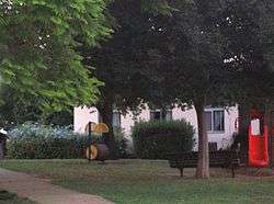
Matzuva (Hebrew: מַצּוּבָה), also known as Matzuba, is a kibbutz in the Western Galilee in northern Israel. Located south of the development town of Shlomi, it falls under the jurisdiction of Mateh Asher Regional Council. In 2017 it had a population of 1,166.[1]
History
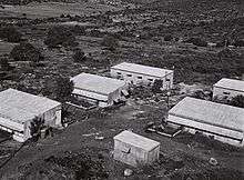
The village was established in 1940 by immigrants from Germany, members of the Maccabi HaTzair youth movement. It was named after the nearby Pi Matzuba known in antiquities, a place mentioned in the Tosefta (Shevi'it 4:8-ff.) and in the 3rd century Mosaic of Rehob.[2] The name is believed to have been derived from mṣwbh, a Semitic root, meaning "pyramid; pyramidal pile".[3]
After the 1948 Arab–Israeli War, it expanded on land belonging to the Palestinian village of al-Bassa, which was depopulated in that war.[4]
Economy
Due to economic problems, the kibbutz textile factory closed down in 2003.[5]
See also
References
- 1 2 "List of localities, in Alphabetical order" (PDF). Israel Central Bureau of Statistics. Retrieved August 26, 2018.
- ↑ Haltrecht, Ephraim (1948). "Pi-ha-Masuba". Bulletin of the Jewish Palestine Exploration Society: Israel Exploration Society: 43. JSTOR 23727325. .
- ↑ p. 103 in: Zadok, Ran (1995–1997). "A Preliminary Analysis of Ancient Survivals in Modern Palestinian Toponymy". Mediterranean Language Review. 9: 93–171. JSTOR 10.13173/medilangrevi.9.1997.0093.
- ↑ Khalidi, Walid (1992). All That Remains: The Palestinian Villages Occupied and Depopulated by Israel in 1948. Washington D.C.: Institute for Palestine Studies. pp. 8–9. ISBN 0-88728-224-5.
- ↑ Employees petition to liquidate Kibbutz Matzuva