Matsapha Airport
| Matsapha Airport | |||||||||||
|---|---|---|---|---|---|---|---|---|---|---|---|
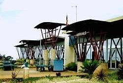 The terminal in 2004 | |||||||||||
| Summary | |||||||||||
| Airport type | Public | ||||||||||
| Operator | Swaziland Civil Aviation Authority (SWACAA) | ||||||||||
| Location | Manzini, Swaziland | ||||||||||
| Elevation AMSL | 2,075 ft / 632 m | ||||||||||
| Coordinates | 26°31′44″S 031°18′27″E / 26.52889°S 31.30750°ECoordinates: 26°31′44″S 031°18′27″E / 26.52889°S 31.30750°E | ||||||||||
| Map | |||||||||||
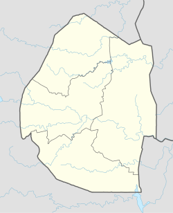 MTS Location of the airport in Swaziland | |||||||||||
| Runways | |||||||||||
| |||||||||||
Matsapha Airport (IATA: MTS, ICAO: FDMS) is an airport located near Manzini, a city in Manzini District of Swaziland. It serves flights of the Swazi Government and mercy flights.[4]
Although a new airport for Manzini, King Mswati III International Airport, was inaugurated in March 2014, Airlink chose to continue flying to Mastapha. However, the Swaziland Civil Aviation Authority (SWACAA) required the airline to end flights to Matsapha on 29 September 2014 and switch to King Mswati III Airport the following day.[5]
Facilities
The airport is at an elevation of 2,075 feet (632 m) above mean sea level, the runway elevation is 2,075 feet (632 m). It has one runway designated 07/25 with an asphalt surface measuring 2,600 by 45 metres (8,530 ft × 148 ft).[1]
The Matsapha non-directional beacon (Ident: MS) is located off the approach threshold of Runway 25. The Matsapha VOR-DME (Ident: VMS) is located on the field.[6][7]
See also

- List of airports in Swaziland
- Transport in Swaziland
References
- 1 2 Airport information for FDMS from DAFIF (effective October 2006)
- ↑ Airport information for Matsapha Airport at Great Circle Mapper.
- ↑ "Matsapha Airport". Google Maps. Google. Retrieved 18 June 2018.
- ↑ "Matsapha Airport". Swaziland Civil Aviation Authority. Retrieved 13 February 2016.
- ↑ "Swaziland: Airlink Forced to Use King's Airport". allAfrica.com. 22 August 2014. Retrieved 13 February 2016.
- ↑ "Matsapha VOR-DME (VMS) @ OurAirports". ourairports.com. Retrieved 2018-08-26.
- ↑ "SkyVector: Flight Planning / Aeronautical Charts". skyvector.com. Retrieved 2018-08-26.
External links
- OpenStreetMap - Matsapha Airport
- Everything about Matsapha/Manzini International Airport – History, recent statistics, airlines, planespotting, parking and car rental
- Current weather for Manzini/Matsapa Airport, Swaziland (FDMS) at NOAA/NWS
- Accident history for Manzini – Matsapha International Airport at Aviation Safety Network
| Main Roads |  | |
|---|---|---|
| Rail | ||
| Air | ||
| Border posts | ||