Matekane Air Strip
| Matekane Air Strip | |||||||||||
|---|---|---|---|---|---|---|---|---|---|---|---|
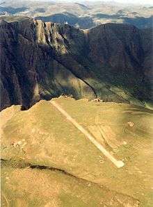 Photo by Bush Pilot Tom Claytor 1993 | |||||||||||
| Summary | |||||||||||
| Airport type | Public | ||||||||||
| Elevation AMSL | 7,544 ft / 2,299 m | ||||||||||
| Coordinates | 29°55′45″S 27°50′54″E / 29.92916°S 27.84822°ECoordinates: 29°55′45″S 27°50′54″E / 29.92916°S 27.84822°E | ||||||||||
| Map | |||||||||||
 MTK Location within Lesotho | |||||||||||
| Runways | |||||||||||
| |||||||||||
|
Source: Google Maps[1] | |||||||||||
Matekane Air Strip is a high elevation airstrip serving Matekane, Lesotho, with a runway that extends to the edge of a 500 m (1,600 ft) cliff. The runway is often used by charity organizations and doctors to access remote villages in the area, and is known as one of the world's scariest runways.[2]
The Maseru VOR-DME (Ident: MZV) is located 30.3 nautical miles (56.1 km) northwest of the airstrip.[3]
See also

- Transport in Lesotho
- List of airports in Lesotho
- List of shortest runways
References
- ↑ Google Maps - Matekane
- ↑ Farhad Heydari (October 2009). "The World's Scariest Runways". Travel & Leisure. Retrieved 12 February 2011.
- ↑ "Mazenod VOR-DME (MZV) @ OurAirports". ourairports.com. Retrieved 2018-08-21.
External links
This article is issued from
Wikipedia.
The text is licensed under Creative Commons - Attribution - Sharealike.
Additional terms may apply for the media files.