Massachusetts Route 148
| ||||
|---|---|---|---|---|
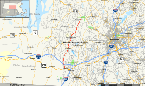 Map of Worcester County in central Massachusetts with Route 148 highlighted in red | ||||
| Route information | ||||
| Maintained by MassDOT | ||||
| Length | 19.68 mi[1] (31.67 km) | |||
| Major junctions | ||||
| South end |
| |||
| North end |
| |||
| Location | ||||
| Counties | Worcester | |||
| Highway system | ||||
| ||||

Route 148 is a south–north highway in central Massachusetts. The road is 20 miles (32 km) long and travels between U.S. Route 20 (US 20) in Sturbridge and Route 122 in Oakham. It travels entirely in Worcester County.
Route description
Route 148 begins at US 20 in Fiskdale, a village in Sturbridge. The highway runs north under Interstate 90 (the Massachusetts Turnpike) without an interchange and past the Tantasqua Regional High School before entering Brookfield, where there is a very brief concurrency with Route 9 in the center of the town. Route 148 then enters North Brookfield and becomes concurrent with Route 67 through the center of the town. After the two highways diverge, Route 148 passes through the southeastern corner of New Braintree for less than one-half-mile (0.80 km) and then enters Oakham, where the highway ends at Route 122.
History
Route 148 was extended after 1986 from the southern intersection with Route 67 in North Brookfield to Route 122 in Oakham;[2] however, signage for the highway north of Route 67 is very spotty.
Major intersections
The entire route is in Worcester County.
| Location | mi[3] | km | Destinations | Notes | |||
|---|---|---|---|---|---|---|---|
| Sturbridge | 0.0 | 0.0 | |||||
| Brookfield | 7.6 | 12.2 | Western terminus of Route 9/148 concurrency | ||||
| 7.6 | 12.2 | Eastern terminus of Route 9/148 concurrency | |||||
| North Brookfield | 10.6 | 17.1 | Southern terminus of Route 67/148 concurrency | ||||
| 12.3 | 19.8 | Northern terminus of Route 67/148 concurrency | |||||
| Oakham | 19.7 | 31.7 | |||||
1.000 mi = 1.609 km; 1.000 km = 0.621 mi
| |||||||
References
- ↑ Executive Office of Transportation, Office of Transportation Planning - 2007 Road Inventory
- ↑ Neilbert.com Massachusetts Route Log
- ↑ Google (April 2, 2017). "Massachusetts Route 148" (Map). Google Maps. Google. Retrieved April 2, 2017.
External links
| Wikimedia Commons has media related to Massachusetts Route 148. |