Old Sturbridge Village
Old Sturbridge Village is a living museum located in Sturbridge, Massachusetts which recreates life in rural New England during the 1790s through 1830s. It is the largest living museum in New England, covering more than 200 acres (80 hectares). The Village includes 59 antique buildings, three water-powered mills, and a working farm. The museum is popular among tourists and for educational field trips. Costumed interpreters speaking in modern English help visitors understand 19th-century life.

History
Prior to European colonization, the Nipmuck people inhabited the Quinebaug River. In the early 19th century, the land on which Old Sturbridge Village now stands was a farm owned by David Wight which included a sawmill, a gristmill, and a millpond. The millpond was dug in 1795 and still powers the mills today. In 1795, Wight's son went to Boston to conduct some business on behalf of his father. While in Boston, he bought tickets to the Harvard Lottery which was a fund-raising technique for Harvard College. He won $5,000 (equivalent to $78.2 thousand in today's dollars).[1]. He gave his father money to pay off the mortgage on his farm and logged the timber of the cedar swamp which today is the millpond. After the logging was complete, they dug the pond with a team of oxen and a scoop. This entire process took two and a half years.
George Washington Wells started a small spectacle shop in Southbridge, Massachusetts in the 1840s which became the American Optical Company. His sons Channing, Albert (called "AB"), and Cheney followed him into the business, which continued to expand. In 1926, AB began to shop for antiques, and this influenced Cheney to collect early American timepieces and Channing to collect fine furniture. By the early 1930s, AB had more than 45 rooms full of antiques in his Southbridge home.
The Wells family and others formed the Wells Historical Museum in 1935, gave it title to the various collections, and charged it with the care and exhibition of the artifacts. In July 1936, the Museum's trustees met to determine how the collections would best be presented to the public. AB wanted to create a small cluster of buildings in a horseshoe around a common, but his son George B proposed creating a live village with operating shops and a source of water power. Within a week of the meeting, the Museum purchased David Wight's farm and soon after hired Malcolm Watkins as the first curator of the museum, which they called Quinnebaug Village in honor of the river. Architect Arthur Shurcliff was called in to help lay out a suitable country landscape. By 1941, the Fitch House, the Miner Grant Store, and the Richardson House (now the Parsonage) were on the common and the Gristmill was in operation.
After a pause for World War II, George B.'s wife Ruth became acting director of the Village. They changed its name to Old Sturbridge Village and opened it on June 8, 1946. Attendance climbed, mostly through word of mouth. In a 1950 article in The Saturday Evening Post, the village was featured as "The Town That Wants to be Out of Date". By 1955, it acquired the Meetinghouse from the Fiskdale neighborhood of Sturbridge, the Salem Towne House from Charlton, Massachusetts, the Fenno House, the Friends Meetinghouse, the Pliny Freeman House, the Printing Office, and the District School.
On August 18, 1955, gale-force winds and a torrential downpour from Hurricane Diane created flood waters that broke dams in surrounding towns and flooded the Village, stranding 15 staff members. The Freeman Farmhouse was flooded and the Covered Bridge was swept off its foundation. Helicopters kept staff members supplied for three days until the waters receded. The damage was estimated to be $250,000 in 1955 dollars, but Village employees managed to re-open the Village in just nine days.
Structures and exhibits
Old Sturbridge Village has more than 40 structures, including restored buildings purchased and relocated from around New England, as well as some authentic reconstructions, and the entire village is divided into three main sections. The Center Village represents the center of town, with the town green as its focal point. Countryside consists of outlying farms and shops. The Mill Neighborhood features various commercial structures that rely upon the millpond for their power.
Center Village
The Center Village contains:
- Friends Meetinghouse - a meetinghouse of the Religious Society of Friends, known as Quakers
- Center Meetinghouse - churches often served as a location for town meetings, elections, lectures, and political events
- Tin Shop - tin imported from England was used to make a variety of household goods
- Salem Towne House - a prosperous farmer's home
- Law Office - a small, free-standing office of a lawyer
- Parsonage - the home of a Congregational minister and his family
- Asa Knight Store - a country store, transported from its original location in Vermont
- Thompson Bank - a bank that was originally located in Thompson, Connecticut
- Fenno House - a historic house with exhibits that highlight domestic textile production
- Fitch House - a residence exhibit that highlights children and family life
- Small House - a small home based on those of less affluent families and renters
- Printing Office
- Cider Mill - a horse-powered mill for the production of hard cider
- Shoe Shop - a historic ten footer, which was a small backyard shop structure built in the 18th and 19th centuries in New England to serve as a shoemaker's shop. Such structures were usually 10 feet (3.0 m) by 10 feet (3.0 m) in area. They were forerunners of the large shoe factories that developed in New England later in the 19th century.[2]
- Town Pound - for the confinement of livestock found wandering loose
- Bullard Tavern - an early 19th-century tavern room
- The Stage Coach - a stage coach marked "Hartford & Worcester" which makes trips through Center Village
The Countryside
The Countryside section contains:
- Freeman Farmhouse - a typical New England farm of approximately 70 acres (280,000 m2) with barn, outbuildings, and fields
- Blacksmith Shop - a shop where farm implements and other hardware were made and repaired and horses and oxen were shod
- Bixby House - the home of the blacksmith
- Cooper Shop - where wooden barrels, buckets, and pails were made
- Pottery Shop - New England potters made utilitarian items out of local clay, such as milkpans, mugs, crocks, flowerpots, and mixing bowls
- District School - a typical publicly funded one-room school
- Covered Bridge - Covered bridges extended the longevity of wooden bridges in the harsh New England weather.
The Mill Neighborhood
Mill Neighborhood features:
- Gristmill - uses water power to turn a 3,000-pound millstone for grinding grain
- Sawmill - a working replica of an "up-and-down" sawmill powered by a reaction-type waterwheel
- Carding Mill - a water-driven facility to prepare wool for spinning
Collections
Old Sturbridge Village has several buildings devoted to displaying their assorted collections of early American antiques.
- Firearms - many displays feature firearms from colonial America through the post-Civil War era
- Glass - there are three categories of displays: blown glass, molded glass, and pressed glass
- Lighting Devices - early lighting devices from ancient oil lamps and candles to whale oil, camphene, and argand lamps
- Herb Garden - a living collection of native and heirloom varieties of ornamental plants and those used for cooking, medicine, dying cloth, and making traditional crafts
Scenes from Interactive Exhibits
 Food preparation demonstration in an early 19th-century kitchen
 A potter produces handmade goods on an old-fashioned wheel
 A shopkeeper displays typical early 1800s goods
 A woman demonstrates spinning wool into yarn
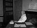 Lawyer in the pre-Civil War law office
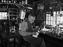 A tinsmith demonstrates how tinware was produced
See also
| Wikimedia Commons has media related to Old Sturbridge Village. |
References
- ↑ Federal Reserve Bank of Minneapolis Community Development Project. "Consumer Price Index (estimate) 1800–". Federal Reserve Bank of Minneapolis. Retrieved January 2, 2018.
- ↑ Hunter, Ethel A., The Ten-Footers of New England in Parks, Roger, editor, The New England Galaxy: The best of 20 years from Old Sturbridge Village, Chester Connecticut: Globe Pequot Press, 1980, pp. 134-139, ISBN 0-87106-040-X
External links
Coordinates: 42°06′31.88″N 72°05′55.31″W / 42.1088556°N 72.0986972°W