Peach Bottom Township, York County, Pennsylvania
| Peach Bottom Township, Pennsylvania | |
|---|---|
| Township | |
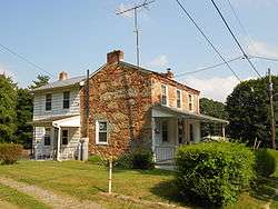 One of the four Coulsontown Cottages in Coulsontown | |
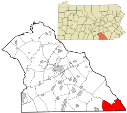 Location in York County and the state of Pennsylvania. | |
| Country | United States |
| State | Pennsylvania |
| County | York |
| Settled | 1735 |
| Incorporated | 1815 |
| Government | |
| • Type | Board of Supervisors |
| Area[1] | |
| • Total | 29.76 sq mi (77.08 km2) |
| • Land | 29.21 sq mi (75.66 km2) |
| • Water | 0.55 sq mi (1.41 km2) |
| Population (2010) | |
| • Total | 4,813 |
| • Estimate (2016)[2] | 4,951 |
| • Density | 169.47/sq mi (65.43/km2) |
| Time zone | UTC-5 (Eastern (EST)) |
| • Summer (DST) | UTC-4 (EDT) |
| Area code(s) | 717 |
| FIPS code | 42-133-58560 |
| Historical population | |||
|---|---|---|---|
| Census | Pop. | %± | |
| 2000 | 4,412 | — | |
| 2010 | 4,813 | 9.1% | |
| Est. 2016 | 4,951 | [2] | 2.9% |
| U.S. Decennial Census[3] | |||
Peach Bottom Township is a township in York County, Pennsylvania, 60 miles (97 km) south of Harrisburg. The population was 4,813 at the 2010 census.[4]
Peach Bottom Township was so named on account of peach trees growing near a river (bottom).[5] Peach Bottom Nuclear Generating Station was built in 1958.
History
The Coulsontown Cottages Historic District, Delta Trestle Bridge, Maryland and Pennsylvania Railroad, and Scott Creek Bridge-North, Maryland and Pennsylvania Railroad are listed on the National Register of Historic Places.[6]
Geography
According to the United States Census Bureau, the township has a total area of 29.6 square miles (77 km2), of which 29.2 square miles (76 km2) is land and 0.4 square miles (1.0 km2), or 1.28%, is water. The southern boundary of the township is the Maryland-Pennsylvania border (the Mason–Dixon Line), and the eastern border is the Susquehanna River. The township surrounds on three sides the borough of Delta, located along the state line.
Demographics
As of the census[7] of 2000, there were 4,412 people, 1,528 households, and 1,216 families residing in the township. The population density was 151.0 people per square mile (58.3/km²). There were 1,852 housing units at an average density of 63.4/sq mi (24.5/km²). The racial makeup of the township was 96.60% White, 1.99% African American, 0.36% Native American, 0.32% Asian, 0.09% from other races, and 0.63% from two or more races. Hispanic or Latino of any race were 0.57% of the population.
There were 1,528 households out of which 42.0% had children under the age of 18 living with them, 67.1% were married couples living together, 6.5% had a female householder with no husband present, and 20.4% were non-families. 16.4% of all households were made up of individuals and 6.4% had someone living alone who was 65 years of age or older. The average household size was 2.87 and the average family size was 3.20.
In the township the population was spread out with 29.2% under the age of 18, 6.3% from 18 to 24, 33.7% from 25 to 44, 21.3% from 45 to 64, and 9.5% who were 65 years of age or older. The median age was 36 years. For every 100 females there were 106.9 males. For every 100 females age 18 and over, there were 106.5 males.
The median income for a household in the township was $42,778, and the median income for a family was $45,753. Males had a median income of $35,043 versus $24,468 for females. The per capita income for the township was $17,005. About 2.5% of families and 3.9% of the population were below the poverty line, including 2.4% of those under age 18 and 2.8% of those age 65 or over.
References
- ↑ "2016 U.S. Gazetteer Files". United States Census Bureau. Retrieved Aug 14, 2017.
- 1 2 "Population and Housing Unit Estimates". Retrieved June 9, 2017.
- ↑ "Census of Population and Housing". Census.gov. Retrieved June 4, 2016.
- ↑ "Race, Hispanic or Latino, Age, and Housing Occupancy: 2010 Census Redistricting Data (Public Law 94-171) Summary File (QT-PL), Peach Bottom township, York County, Pennsylvania". U.S. Census Bureau, American FactFinder 2. Retrieved October 17, 2011.
- ↑ Moyer, Armond; Moyer, Winifred (1958). The origins of unusual place-names. Keystone Pub. Associates. p. 99.
- ↑ National Park Service (2010-07-09). "National Register Information System". National Register of Historic Places. National Park Service.
- ↑ "American FactFinder". United States Census Bureau. Retrieved 2008-01-31.
Coordinates: 39°44′00″N 76°17′59″W / 39.73333°N 76.29972°W