Marydel, Maryland
| Marydel, Maryland | |
|---|---|
| Town | |
_at_Railroad_Avenue_in_Marydel%2C_Caroline_County%2C_Maryland.jpg) Main Street in Marydel | |
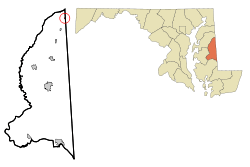 Location of Marydel, Maryland | |
 Marydel Location within the U.S. state of Maryland  Marydel Marydel (the US) | |
| Coordinates: 39°6.8′N 75°44.8′W / 39.1133°N 75.7467°WCoordinates: 39°6.8′N 75°44.8′W / 39.1133°N 75.7467°W | |
| Country |
|
| State |
|
| County |
|
| Incorporated | 1929 |
| Area[1] | |
| • Total | 0.08 sq mi (0.21 km2) |
| • Land | 0.08 sq mi (0.21 km2) |
| • Water | 0 sq mi (0 km2) |
| Elevation | 59 ft (18 m) |
| Population (2010)[2] | |
| • Total | 141 |
| • Estimate (2016)[3] | 141 |
| • Density | 1,800/sq mi (670/km2) |
| Time zone | UTC-5 (Eastern (EST)) |
| • Summer (DST) | UTC-4 (EDT) |
| ZIP code | 21649 |
| Area code(s) | 410 |
| FIPS code | 24-51025 |
| GNIS feature ID | 0590751 |
Marydel is an incorporated town in Caroline County, Maryland.[4][5] The population was 141 at the 2010 United States Census. It is named after its location, being partially located in Maryland and partially in Delaware. Marydel was originally known as Halltown.
Geography
Marydel is a town in Caroline County, Maryland located at 39°6.8′N 75°44.8′W / 39.1133°N 75.7467°W (39.1130, -75.7468).[6]
According to the United States Census Bureau, the town has a total area of 0.08 square miles (0.21 km2), all of it land.[1]
History
Marydel is home to a large community of Hispanic/Latino-Americans. The majority of the Latinos in Marydel are Guatemalans of Mayan descent who came from poor, rural, mountainous regions and speak Mam (a Mayan language) rather than Spanish. Due to their origins in the agricultural, rural regions of Guatemala, many Guatemalan immigrants felt at home living in rural Caroline County. Guatemalans of Mayan descent are discriminated against in their home country and many do not speak Spanish, making it difficult for some Guatemalan immigrants to attain legal residency or citizenship, though many Guatemalans in Marydel have become permanent residents and American citizens.[7][8]
Demographics
| Historical population | |||
|---|---|---|---|
| Census | Pop. | %± | |
| 1880 | 98 | — | |
| 1930 | 127 | — | |
| 1940 | 78 | −38.6% | |
| 1950 | 110 | 41.0% | |
| 1960 | 130 | 18.2% | |
| 1970 | 176 | 35.4% | |
| 1980 | 152 | −13.6% | |
| 1990 | 143 | −5.9% | |
| 2000 | 147 | 2.8% | |
| 2010 | 141 | −4.1% | |
| Est. 2016 | 141 | [3] | 0.0% |
| U.S. Decennial Census[9] | |||
2010 census
As of the census[2] of 2010, there were 141 people, 36 households, and 24 families residing in the town. The population density was 1,762.5 inhabitants per square mile (680.5/km2). There were 50 housing units at an average density of 625.0 per square mile (241.3/km2). The racial makeup of the town was 46.1% White, 3.5% African American, 0.7% Native American, 1.4% Asian, 46.1% from other races, and 2.1% from two or more races. Hispanic or Latino of any race were 53.9% of the population.
There were 36 households of which 44.4% had children under the age of 18 living with them, 58.3% were married couples living together, 2.8% had a female householder with no husband present, 5.6% had a male householder with no wife present, and 33.3% were non-families. 22.2% of all households were made up of individuals and 13.9% had someone living alone who was 65 years of age or older. The average household size was 3.92 and the average family size was 4.83.
The median age in the town was 26.1 years. 36.2% of residents were under the age of 18; 12.6% were between the ages of 18 and 24; 25.5% were from 25 to 44; 14.8% were from 45 to 64; and 10.6% were 65 years of age or older. The gender makeup of the town was 51.8% male and 48.2% female.
2000 census
As of the census[10] of 2000, there were 147 people, 47 households, and 32 families residing in the town. The population density was 2,353.5 people per square mile (946.0/km²). There were 52 housing units at an average density of 832.5 per square mile (334.6/km²). The racial makeup of the town was 85.71% White, 6.80% African American, 2.72% Native American, 0.68% Asian, and 4.08% from two or more races. Hispanic or Latino of any race were 8.16% of the population.
There were 47 households out of which 38.3% had children under the age of 18 living with them, 48.9% were married couples living together, 17.0% had a female householder with no husband present, and 29.8% were non-families. 25.5% of all households were made up of individuals and 8.5% had someone living alone who was 65 years of age or older. The average household size was 3.00 and the average family size was 3.42.
In the town, the population was spread out with 28.6% under the age of 18, 12.2% from 18 to 24, 31.3% from 25 to 44, 18.4% from 45 to 64, and 9.5% who were 65 years of age or older. The median age was 32 years. For every 100 females, there were 116.2 males. For every 100 females age 18 and over, there were 133.3 males.
The median income for a household in the town was $25,250, and the median income for a family was $26,500. Males had a median income of $22,083 versus $12,083 for females. The per capita income for the town was $12,379. There were 20.8% of families and 16.5% of the population living below the poverty line, including 24.2% of under eighteens and none of those over 64.
See also
References
- 1 2 "US Gazetteer files 2010". United States Census Bureau. Archived from the original on 2012-01-24. Retrieved 2013-01-25.
- 1 2 "American FactFinder". United States Census Bureau. Retrieved 2013-01-25.
- 1 2 "Population and Housing Unit Estimates". Retrieved June 9, 2017.
- ↑ "Maryland Manual". Marydel Maryland. Retrieved 8 October 2015.
- ↑ "Marydel, Maryland (town)". Geographic Names Information System. United States Geological Survey.
- ↑ "US Gazetteer files: 2010, 2000, and 1990". United States Census Bureau. 2011-02-12. Retrieved 2011-04-23.
- ↑ "Guatemalans seek better life on Shore Immigrants: The detainment of 107 suspected illegal immigrants has shaken the tranquil lives of Latino residents at a Caroline Co. trailer park". The Baltimore Sun. Retrieved 2017-04-06.
- ↑ "Rev. LaBarge to leave Marydel charge". The Star Democrat. Retrieved 2017-04-06.
- ↑ "Census of Population and Housing". Census.gov. Retrieved June 4, 2015.
- ↑ "American FactFinder". United States Census Bureau. Retrieved 2008-01-31.
Municipalities and communities of Caroline County, Maryland, United States | ||
|---|---|---|
| Towns | 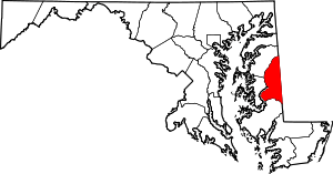 | |
| CDPs | ||
| Unincorporated communities | ||
| Footnotes | ‡This populated place also has portions in an adjacent county or counties | |