Martinsville Road Covered Bridge
|
Martinsville Road Covered Bridge | |
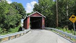 Bridge in 2013 | |
 | |
| Nearest city | Martinsville, Ohio |
|---|---|
| Coordinates | 39°19′47″N 83°50′06″W / 39.32972°N 83.83500°WCoordinates: 39°19′47″N 83°50′06″W / 39.32972°N 83.83500°W |
| Area | less than one acre |
| Built | 1871 |
| Built by | Wall, Zimri |
| Architectural style | Multiple kingpost |
| NRHP reference # | 74001421[1] |
| Added to NRHP | September 10, 1974 |
The Martinsville Road Covered Bridge, west of Martinsville, Ohio in Clark Township, Clinton County, Ohio, was built in 1871. It was listed on the National Register of Historic Places in 1974.[1]
It is a multiple kingpost covered bridge.[1]
It spans the Todds Fork of the Little Miami River and is 72 feet (22 m) long.[2]
It is covered in the Ohio Historic Places Dictionary.[3]
References
- 1 2 3 National Park Service (2013-11-02). "National Register Information System". National Register of Historic Places. National Park Service.
- ↑ "Martinsville Road Covered Bridge". ClintonCountyOhio.Com. Retrieved September 6, 2018.
- ↑ Lorrie K. Owen, ed. (1999). "Ohio Historic Places Dictionary, Volume 2". Somerset Publishers, Inc. p. 152.
| Topics | |
|---|---|
| Lists by states |
|
| Lists by insular areas | |
| Lists by associated states | |
| Other areas | |
| |
This article is issued from
Wikipedia.
The text is licensed under Creative Commons - Attribution - Sharealike.
Additional terms may apply for the media files.