Marsh Mill, California
| Marsh Mill | |
|---|---|
| Unincorporated community | |
 Marsh Mill Location in California  Marsh Mill Marsh Mill (the US) | |
| Coordinates: 39°26′40″N 120°42′13″W / 39.44444°N 120.70361°WCoordinates: 39°26′40″N 120°42′13″W / 39.44444°N 120.70361°W | |
| Country |
|
| State |
|
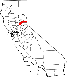
| County | Nevada County |
| Elevation[1] | 5,843 ft (1,781 m) |
Marsh Mill is an unincorporated community in Nevada County, California.[1] It lies at an elevation of 5843 feet (1781 m).[1] Marsh Mill is located 2 miles (3.2 km) east of Graniteville.[2]
References
ILLUSTRATIONS AND PHOTOGRAPHS
ILLUSTRATIONS AND PHOTOGRAPHS
The Southern 70 acres version of El Capitan. Massive rock formation, hidden granite cliff on the left side covered by the trees
The Southern 70 acres version of El Capitan. Massive rock formation, hidden granite cliff on the left side covered by the trees
This article is issued from
Wikipedia.
The text is licensed under Creative Commons - Attribution - Sharealike.
Additional terms may apply for the media files.