La Barr Meadows, California
| La Barr Meadows | |
|---|---|
| Former settlement | |
 La Barr Meadows Location in California | |
| Coordinates: 39°10′29″N 121°02′39″W / 39.17472°N 121.04417°WCoordinates: 39°10′29″N 121°02′39″W / 39.17472°N 121.04417°W | |
| Country |
|
| State |
|
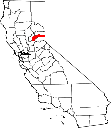
| County | Nevada County |
| Elevation[1] | 2,484 ft (757 m) |
| Time zone | UTC-8 (Pacific (PST)) |
| • Summer (DST) | UTC-7 (PDT) |
La Barr Meadows is a former settlement in Nevada County, California, located near Grass Valley.[2] It was listed on an official map as of 1949.[3]
References
- ↑ U.S. Geological Survey Geographic Names Information System: La Barr Meadows, California
- ↑ "NEVADA COUNTY, CALIFORNIA". calsign.com. Archived from the original on 2008-11-20. Retrieved 2009-06-03.
- ↑ Durham, David L. (1998). California's Geographic Names: A Gazetteer of Historic and Modern Names of the State. Quill Driver Books. p. 509. ISBN 1-884995-14-4.
This article is issued from
Wikipedia.
The text is licensed under Creative Commons - Attribution - Sharealike.
Additional terms may apply for the media files.