Marienthal, Kansas
| Marienthal, Kansas | |
|---|---|
| Unincorporated community | |
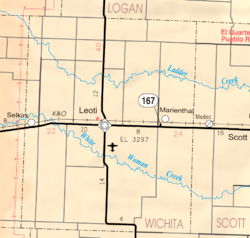 KDOT map of Wichita County (legend) | |
 Marienthal  Marienthal | |
| Coordinates: 38°29′15″N 101°12′47″W / 38.48750°N 101.21306°WCoordinates: 38°29′15″N 101°12′47″W / 38.48750°N 101.21306°W[1] | |
| Country | United States |
| State | Kansas |
| County | Wichita |
| Elevation[1] | 3,215 ft (980 m) |
| Time zone | UTC-6 (CST) |
| • Summer (DST) | UTC-5 (CDT) |
| ZIP code | 67863 |
| Area code | 620 |
| FIPS code | 20-44600 [1] |
| GNIS ID | 471501 [1] |
Marienthal is an unincorporated community (and census-designated place) in Wichita County, Kansas, United States.
History
In 1892, the community was founded by a group of immigrant Volga Germans; they named it after their previous hometown of Marienthal (Tonkoschurovka), Russia (today Sovetskoya, Russia), located in the district of Saratov, on the east side of the Volga River. The post office was established March 18, 1902.[2] Marienthal now consists of roughly 100 people, a Catholic church,[3] a post office, a flour mill,[4] a substance abuse treatment center, a trucking company, a bar and a grain elevator.
References
- 1 2 3 4 Geographic Names Information System (GNIS) details for Marienthal, Kansas; United States Geological Survey (USGS); October 13, 1978.
- ↑ "Kansas Post Offices, 1828-1961". Kansas Historical Society. Archived from the original on 9 October 2013. Retrieved 27 June 2014.
- ↑ St. Mary Church.
- ↑ Heartland Mill.
External links
- Wichita County High School
- Wichita County Maps: Current, Historic, KDOT
Municipalities and communities of Wichita County, Kansas, United States | ||
|---|---|---|
| City | 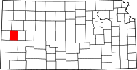 | |
| CDP | ||
| Unincorporated communities | ||
| Ghost towns | ||
This article is issued from
Wikipedia.
The text is licensed under Creative Commons - Attribution - Sharealike.
Additional terms may apply for the media files.