Marambaia Formation
| Marambaia Formation Stratigraphic range: Paleocene-Pliocene ~65–2.6 Ma | |
|---|---|
| Type | Geological formation |
| Unit of | Itamambuca Group |
| Underlies | Sepetiba Formation |
| Overlies | Itajaí-Açu Fm., Juréia Fm. |
| Thickness | up to 2,700 m (8,900 ft) |
| Lithology | |
| Primary | Shale, marl |
| Other | Sandstone |
| Location | |
| Coordinates | 26°6′S 43°43′W / 26.100°S 43.717°WCoordinates: 26°6′S 43°43′W / 26.100°S 43.717°W |
| Region | Santos Basin, South Atlantic |
| Country |
|
| Type section | |
| Named for | Restinga da Marambaia |
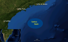 Location of the Santos Basin | |
The Marambaia Formation (Portuguese: Formacão Marambaia) is a geological formation of the Santos Basin offshore of the Brazilian states of Rio de Janeiro, São Paulo, Paraná and Santa Catarina. The predominantly shale and marl formation dates to the Tertiary period and has a maximum thickness of 2,700 metres (8,900 ft). The formation is a seal and reservoir rock of the Atlanta and Oliva Fields in the Santos Basin.
Etymology
The formation is named after Restinga da Marambaia, Rio de Janeiro.
Description
The Marambaia Formation is between 261 and 2,000 metres (856 and 6,562 ft) thick,[1] and consists of grey shales and light grey marls interbedded with fine-grained turbiditic sandstones. The Marambaia Formation is the deeper lateral equivalent of the Iguape Formation. This formation in places can be found cropping out at sea bottom. The depositional environment is thought to be talus and open marine basin. Biostratigraphic data indicate a Tertiary age.[2]
The formation is a seal,[3] and reservoir rock in the Atlanta and Oliva Fields of the Santos Basin.[4][5]
See also
References
Bibliography
- Clemente, Pilar. 2013. Petroleum geology of the Campos and Santos basins, Lower Cretaceous Brazilian sector of the South Atlantic margin, 1–33. Danmarks Tekniske Universitet. Accessed 2017-09-04.
- Contreras, Jorham. 2011. Seismo-stratigraphy and numerical basin modeling of the southern Brazilian continental margin (Campos, Santos, and Pelotas basins) (PhD thesis), 1–171. Ruprecht-Karls-Universität Heidelberg. Accessed 2017-09-04.
- Kiang Chang, Hung; Mario Luis Assine; Fernando Santos Corrêa; Julio Setsuo Tinen; Alexandre Campane Vidal, and Luzia Koike. 2008. Sistemas petrolíferos e modelos de acumulação de hidrocarbonetos na Bacia de Santos. Revista Brasileira de Geociências 38. 29–46. Accessed 2017-09-04.
- Vieira, Juliana. 2007. Brazil Round 9 - Santos Basin, 1–73. ANP. Accessed 2017-09-04.