Manucoco
| Manucoco | |
|---|---|
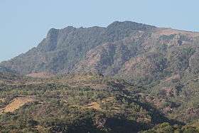 View of Manucoco | |
| Highest point | |
| Elevation | 995 m (3,264 ft) [1] |
| Coordinates | 8°16′14″S 125°34′28″E / 8.27056°S 125.57444°ECoordinates: 8°16′14″S 125°34′28″E / 8.27056°S 125.57444°E |
| Geography | |
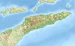 Manucoco Location in East Timor | |
| Location | Atauro Island, East Timor |
Manucoco, also referred to as Gunung Manucoco or Mount Manucoco, is a mountain in the Atauro Island subdistrict of the Dili District of East Timor. It stands near the southern end of Atauro Island, at the western end of Wetar Strait, some 25 km (16 mi) north of Dili, the nation’s capital. The rugged topography of the island’s highlands is a result of the erosion of uplifted, originally submarine, volcanoes from the Neogene period creating narrow, dissected ridges and steep slopes, with Manucoco forming the highest point. The upper levels of the mountain (above an elevation of 700 m (2,300 ft)) still carry patches of tropical semi-evergreen mountain forest in sheltered valleys, covering about 40 km2 (15 sq mi). The mountain, along with the whole of Atauro Island, has been identified as an Important Bird Area by BirdLife International because it supports populations of several of Timor’s and Wetar's restricted-range native bird species.[1]
References
- 1 2 "Atauro Island - Manucoco". Important Bird Areas factsheet. BirdLife International. 2014. Retrieved 2014-03-08.