Manson, Manitoba
| Manson | |
|---|---|
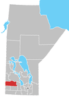
 Manson Location of Manson in Manitoba | |
| Coordinates: 50°08′12″N 101°22′06″W / 50.13667°N 101.36833°WCoordinates: 50°08′12″N 101°22′06″W / 50.13667°N 101.36833°W | |
| Country |
|
| Province |
|
| Region | Westman Region |
| No. 15 | Census Division |
| Elevation | 500 m (1,640 ft) |
| Time zone | UTC−6 (CST) |
| • Summer (DST) | UTC−5 (CDT) |
| Postal Code | R0M 1J0 |
| Area code(s) | 204 |
| NTS Map | 062K03 |
| GNBC Code | GAQBL |
Manson is an unincorporated hamlet in Manitoba, Canada.[1]
It is located thirteen kilometers north of the Trans-Canada Highway along PTH 41 in the Rural Municipality of Archie.
References
- ↑ "Archived copy". Archived from the original on 2011-07-08. Retrieved 2009-05-12.
Division No. 15, Manitoba (Western Manitoba) | ||||
|---|---|---|---|---|
| Towns |
|  | ||
| Villages |
| |||
| Rural municipalities |
| |||
| First Nations | ||||
| Indian reserves | ||||
| Unincorporated communities |
| |||
This article is issued from
Wikipedia.
The text is licensed under Creative Commons - Attribution - Sharealike.
Additional terms may apply for the media files.