Mansiri Himal
| Mansiri Himal | |
|---|---|
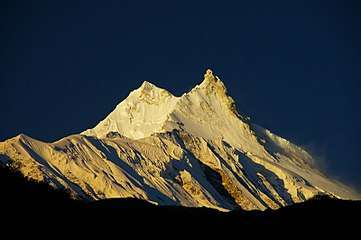 Sunrise over Manaslu | |
| Highest point | |
| Peak | Manaslu |
| Elevation | 8,156 m (26,759 ft) |
| Coordinates | 28°33′00″N 84°34′00″E / 28.55000°N 84.56667°ECoordinates: 28°33′00″N 84°34′00″E / 28.55000°N 84.56667°E |
| Geography | |
| Country | Nepal |
| Districts | Gorkha, Manang and Lamjung |
| Parent range | Himalaya |
| Borders on |
List
|
Mansiri Himal is a small, high subrange[1] of the Himalaya in north-central Nepal, about 100 km northwest of Kathmandu. The Marsyangdi River separates the Mansiri from the Annapurnas to the southwest, then an upper tributary Dudh Khola separates Peri Himal to the northwest. On the east side, the Burhi (Budhi) Gandaki separates the Mansiri from Ganesh Himal, Serang or Sringi Himal and Kutang Himal.[2] All these streams are tributary to the Gandaki.
The Mansiri range is also known as Manaslu Himal or the Gurkha Massif. It contains these peaks among Earth's twenty highest (with at least 500m topographic prominence):
- Manaslu, 8,156 m (26,759 ft), 8th highest
- Himalchuli, 7,893 m (25,896 ft), 18th highest
- Ngadi Chuli, 7,871 m (25,823 ft), 20th highest
The Mansiri range is notable for its local relief. It rises 7,000 m (23,000 ft) above the Marsyangdi valley floor in less than 30 km (18 mi) horizontal distance.
Notes
- ↑ H. Adams Carter (1985). "Classification of the Himalaya" (PDF). American Alpine Journal. American Alpine Club. 27 (59): 109–141. Retrieved April 29, 2011.
- ↑ "H. Adams Carter, op. cit." (PDF): 128.