Manora, Karachi
| Manora منھوڙو منوڑا | |
|---|---|
| Municipality | |
 Manora Point Lighthouse | |
| Coordinates: 24°47′38.6″N 66°58′39.1″E / 24.794056°N 66.977528°ECoordinates: 24°47′38.6″N 66°58′39.1″E / 24.794056°N 66.977528°E | |
| Country |
|
| Province | Sindh |
| City | Karachi |
Manora or Manoro (Sindhi: منهوڙو ٻيٽ) (Urdu: منوڑا) is a small peninsula (2.5 km²) located just south of the Port of Karachi, Sindh, Pakistan. Manora is connected to the mainland by a 12 kilometer long causeway called the Sandspit. Manora and neighboring islands form a protective barrier between Karachi harbor to the north and the Arabian Sea to the south. The western bay of the harbor contains endangered mangrove forests which border the Sandspit and Manora island. To the east is Karachi Bay and the beach towns of Kiamari and Clifton. The peninsula is located at 24°48′00″N 66°58′00″E / 24.80000°N 66.96667°E (24.800000, 66.970000). There are several ethnic groups including Muhajirs, Punjabis, Sindhis, Christians, Kashmiris, Seraikis, Pakhtuns, Balochis, Brahuis, Memons, Bohras and Ismailis.
History

The area of Karachi was known to the ancient Greeks by many names: Krokola, the place where Alexander the Great camped to prepare a fleet for Babylonia after his campaign in the Indus valley; 'Morontobara' island (ancient Manora island near Karachi harbour), from where Alexander's admiral Nearchus set sail; and Barbarikon (Βαρβαρικόν), a port of the Indo-Greek Bactrian kingdom. Alexander's writers:
- Then making their way through two rocks, so close together that the oar-blades of the ships touched the rocks to port and starboard, they moored at Morontobara, after sailing some three hundred stades. The harbour is spacious, circular, deep, and calm, but its entrance is narrow. They called it, in the natives' language, 'The Ladies' Pool,' since a lady was the first sovereign of this district. When they had got safe through the rocks, they met great waves, and the sea running strong; and moreover it seemed very hazardous to sail seaward of the cliffs. For the next day, however, they sailed with an island on their port beam, so as to break the sea, so close indeed to the beach that one would have conjectured that it was a channel cut between the island and the coast. The entire passage was of some seventy stades. On the beach were many thick trees, and the island was wholly covered with shady forest. About dawn, they sailed outside the island, by a narrow and turbulent passage; for the tide was still falling. And when they had sailed some hundred and twenty stades they anchored in the mouth of the river Arabis. There was a fine large harbour by its mouth; but there was no drinking water; for the mouths of the Arabis were mixed with sea-water. However, after penetrating forty stades inland they found a water-hole, and after drawing water thence they returned back again. By the harbour was a high island, desert, and round it one could get oysters and all kinds of fish. Up to this the country of the Arabeans extends; they are the last Indians settled in this direction; from here on the territory, of the Oreitans begins.[1]
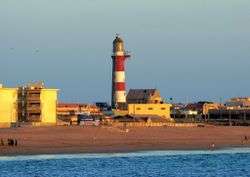
The Manora Island and was visited by Ottoman admiral Seydi Ali Reis and mentioned in his book Mir'ât ül Memâlik in 1554. According to the British historian Eliot, parts of city of Karachi and the island of Manora at port of Karachi constituted the city of Debal. The island was the site of a small fort constructed in the eighteenth century when the port of Karachi traded with Oman and Bahrain. The Kalmati Baloch tribe was settled in Karachi and they raised an army to defend the port from the British invasion. The Kalmati forces were defeated when the Manora Fort was stormed by the British in 1839 because of the strategic location of Karachi. Although the fort is now buried beneath the naval base, the lighthouse is a visible reminder of the British presence having been built in 1889 by the Canadian engineer Alain-Chartier-de-Lotbiniere Joly de Lotbinière[2] to assist vessels approaching Karachi harbor.
The island of Manora has served for more than 50 years as the main base of the Pakistan Navy, with berths for naval vessels located along the eastern edge of the island. The island has been governed as a military cantonment despite being located so close to Karachi. The opening of the new Jinnah Naval Base at Ormara, 250 kilometers away, has meant that approximately half of the naval vessels have moved away from Manora.
Tourism
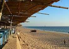
Manora is also a popular picnic spot because of the long sandy beaches along the southern edge of the island, which merge into the beaches of the Sandspit and then extend several kilometers to the beaches at Hawkesbay. At the southeastern end of Manora island is the tallest lighthouse (28 m or 91 feet (28 m) high) with a range of 26 nautical miles Manora Light House in Pakistan. The island lies approximately 15–20 minutes by boat ride from mainland Karachi but there are no good hotels available for an overnight stay. For this and other reasons, the Government of Pakistan has been considering developing the island into a tourist destination. The island has been envisioned as an exotic location with natural landscapes such as the beaches and the mangrove forests, and secluded beauty with an upgrade for the lighthouse to add to the quaint feel of the island.
Land development|Development
Pakistan's Ministry of Ports and Shipping signed a memorandum of understanding in 2006 with Dubai World and M/s Limitless + Dubai Islamic Bank for the redevelopment of Manora Island. As part of the development plans, the Karachi Port Trust (KPT) and all military establishments will vacate the island and hand it over to the companies for development. The development will comprise establishing high rise hotels and apartment buildings in the areas.
KPT is planning to link Manoro island with a Harbour Crossing Bridge which will link the West and East Wharfs of KPT. This bridge will reduce the difference between Manora and the areas of Defence and Clifton by almost 30 km.
Demography
There are several ethnic groups in Manora Island including Muhajirs, Punjabis, Sindhis, Kashmiris, Seraikis, Pakhtuns, Balochis, Brahuis, Memons, Bohris, Hindus and Christians.
Religion
The Manora is predomninantly Muslim with small Hindu and Christian minorities. There are several Mosques and one Hindu temple in Manora. Himalaya Mosque is one of the main mosque and it is located near the Manora Cantonment. The Shri Varun Dev Mandir, temple is devoted to Varuna, the god of the oceans in Hindu mythology is located at Manora.
See also
References
- ↑ Arrian, Anabasis Alexandri: Book VIII (Indica) Archived 2008-09-21 at the Wayback Machine.
- ↑ The Royal Engineers Journal, September 1944
External links
- Karachi-Wikioyage
- Pakistan Export Promotion Bureau mention of Manora
- pbase.com/waqas - Photos from Manora