Malpas, Cornwall
Coordinates: 50°14′37″N 5°01′39″W / 50.2436°N 5.0276°W
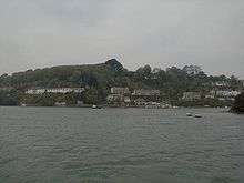
Malpas is a riverside village, and former port, in Cornwall, United Kingdom. It is situated two miles (3 km) southeast of the city of Truro, on the confluence of the Truro River and the Tresillian River.[1]
The village is in the civil parish of St Clement and is a popular centre for boating with navigable waterways to Truro, Falmouth and the sea. Historically, Malpas is known for its ferry service to the Roseland peninsula and there is a myth that this crossing was used by Iseult. Ferries and boat trips still operate from Malpas.[2][3]
Ships were built in Victorian times from Messrs Scoble's boat yard and timber was discharged here. Cargo for Truro was unloaded from ship to barge for transport to the city.[4][5]
Malpas lies within the Cornwall Area of Outstanding Natural Beauty (AONB). Almost a third of Cornwall has AONB designation, with the same status and protection as a National Park. The Truro River from the city to the village form part of the Malpas Estuary SSSI (Site of Special Scientific Interest). It is an important habitat of tidal mudflats, which are feeding grounds for wildfowl and wading birds. The banks of the estuary are also noted for its flora.[6]
References
| Wikimedia Commons has media related to Malpas, Cornwall. |
- ↑ Ordnance Survey: Landranger map sheet 204 Truro & Falmouth ISBN 978-0-319-23149-4
- ↑ Cornwall Council website; ferries; Ferry 17. Retrieved April 2010
- ↑ Enterprise Boats website; services. Retrieved April 2010
- ↑ Nemo (17 April 1879). "Truro News". The Cornishman (40). p. 5.
- ↑ "Truro". The Cornishman (156). 7 July 1881. p. 5.
- ↑ "Malpas Estuary" (PDF). Natural England. 1992. Retrieved 28 December 2015.
Cornwall Portal | |
| Unitary authorities | |
| Major settlements |
|
| Rivers | |
| Topics | |