Malo, Washington
| Malo, Washington | |
|---|---|
| Census-designated place | |
 Malo  Malo | |
| Coordinates: 48°48′06″N 118°36′25″W / 48.80167°N 118.60694°WCoordinates: 48°48′06″N 118°36′25″W / 48.80167°N 118.60694°W | |
| Country | United States |
| State | Washington |
| County | Ferry |
| Area | |
| • Total | 0.12 sq mi (0.3 km2) |
| • Land | 0.12 sq mi (0.3 km2) |
| Elevation | 2,182 ft (665 m) |
| Population (2014)estimated | |
| • Total | 29 |
| • Density | 251/sq mi (97/km2) |
| Time zone | UTC-8 (Pacific (PST)) |
| • Summer (DST) | UTC-7 (PDT) |
| ZIP code | 99150 |
| Area code(s) | 509 |
| GNIS feature ID | 1522664[1] |
Malo is an unincorporated community in Ferry County, Washington, United States. Malo is located on Washington State Route 21 12.5 miles (20.1 km) north-northeast of Republic. Malo has a post office with ZIP code 99150 and had a 2010 census population of 28.[2] The community has the state's largest secondhand store, Malo Trading Post.
Demographics
The city of Malo had an estimated 28 people in 10 households, in which six were family households The mayor is Steven Hines , as of 2017. Average household size was 2.5, and an average family size of three. The population density was 242 inhabitants per square mile (93/km2). There were 18 housing units, with a median house value of $125,000. The median age of these units was 73 years. The median age was 58.2. 2.6% of people were registered Democrats, and 97.9% of people were registered Republicans. 26.55% of people are religious, and the median household income is $45,079.[3][4]
References
- ↑ U.S. Geological Survey Geographic Names Information System: Malo, Washington
- ↑ ZIP Code Lookup
- ↑ "Malo, WA Profile: Facts, Map & Data". hometownlocator.com. Retrieved April 27, 2018.
- ↑ "Best Places to Live in Malo, Washington".
Municipalities and communities of Ferry County, Washington, United States | ||
|---|---|---|
| City | 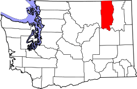 | |
| CDPs | ||
| Other unincorporated communities | ||
| Indian reservation | ||
| Ghost town | ||
| Footnotes | ‡This populated place also has portions in an adjacent county or counties | |