Curlew, Washington
| Curlew, Washington | |
|---|---|
| Census-designated place | |
 Curlew  Curlew | |
| Coordinates: 48°53′08″N 118°35′58″W / 48.88556°N 118.59944°WCoordinates: 48°53′08″N 118°35′58″W / 48.88556°N 118.59944°W | |
| Country | United States |
| State | Washington |
| County | Ferry |
| Area | |
| • Total | 0.76 sq mi (1.96 km2) |
| • Land | 0.76 sq mi (1.96 km2) |
| • Water | 0.0 sq mi (0.0 km2) |
| Elevation | 1,801 ft (549 m) |
| Population (2010 census) | |
| • Total | 118 |
| • Density | 156/sq mi (60.1/km2) |
| Time zone | UTC-8 (Pacific (PST)) |
| • Summer (DST) | UTC-7 (PDT) |
| ZIP code | 99118 |
| Area code(s) | 509 |
| GNIS feature ID | 1518417[1] |
| FIPS code | 53-16165 |
Curlew is an unincorporated community and census-designated place (CDP) located in northwestern Ferry County, Washington, United States, between Malo and Danville on State Route 21. The BNSF Railway ran through the town. The historic Ansorge Hotel is located in Curlew. As of the 2010 census, the population of the community was 118.[2]
Geography
Curlew is located at the confluence of Long Alec Creek and the Kettle River. Its elevation is 1,800 feet (550 m) above sea level.[3] Via State Route 21, it is 21 miles (34 km) south to Republic, the Ferry County seat, and 10 miles (16 km) north to the Canadian border.
One of the most popular sites on the Kettle River in summer is "the Old Swimming Hole" near the center of town. Curlew was a pick-up point for moonshine that was dropped in the Kettle River. The tradition is still celebrated on the first Sunday in June each year during the Curlew Barrel Derby Days. A barrel is set adrift in the Kettle River at the Job Corps Bridge, and local citizens bet on when it will reach town.[4]
History
In 1896 two traders, Guy S. Helphry and J. Walters, set up a general store at an old ferry crossing near the junction of Curlew Creek and the Kettle River. The site around the store grew into a collection of log buildings and other stores. By 1901, a bridge was built across the Kettle River and the community had grown to a population of 200. The community contained two general stores, two saloons, a hotel, two livery stables, a dry goods store and several other businesses. In 1898, a post office was established and the town was named "Curlew". Miners, railroad workers, natives, and others passed through the region. Nearby mines such as Drummer, Lancaster and Panama grew. Curlew never really expanded beyond those early boom years.[5] In the 1950s, there was nearby Curlew Air Force Station, part of the network of Air Defense Command radar stations. The radar site is gone, but the base, 10 miles (16 km) northwest of Curlew up the Kettle River valley, is in use by Job Corps.
References
- ↑ U.S. Geological Survey Geographic Names Information System: Curlew, Washington
- ↑ "Geographic Identifiers: 2010 Demographic Profile Data (G001): Curlew CDP, Washington". U.S. Census Bureau, American Factfinder. Retrieved October 21, 2016.
- ↑ "US Gazetteer files: 2010, 2000, and 1990". United States Census Bureau. 2011-02-12. Retrieved 2011-04-23.
- ↑ "FerryCounty.com Barrel Derby Days". FerryCounty.com. 1998-07-21. Retrieved 2009-02-20.
- ↑ N.L. Barlee (2004), Gold Creeks and Ghost Towns of Northeastern Washington. Hancock House Publishers., ISBN 0-88839-452-7
Municipalities and communities of Ferry County, Washington, United States | ||
|---|---|---|
| City | 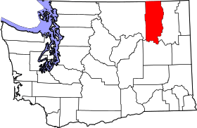 | |
| CDPs | ||
| Other unincorporated communities | ||
| Indian reservation | ||
| Ghost town | ||
| Footnotes | ‡This populated place also has portions in an adjacent county or counties | |