Malnesfjord
| Malnesfjord | |
|---|---|
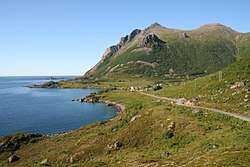 Utskor, on the northeast shore of Malnesfjord | |
 Malnesfjord  Malnesfjord | |
| Location | Nordland/Troms counties, Norway |
| Coordinates | 68°47′10.5″N 14°36′28.9″E / 68.786250°N 14.608028°ECoordinates: 68°47′10.5″N 14°36′28.9″E / 68.786250°N 14.608028°E |
| Basin countries | Norway |
| Max. length | 6.5 kilometres (4.0 mi) |
| Max. width | 1.5 kilometres (0.93 mi) |
| Max. depth | 161 metres (528 ft) |
| Surface elevation | 0 m (0 ft)[1] |
Malnesfjord (English: Malnes Fjord)[2] is a fjord in the municipality of Bø in Vesterålen, Norway.
The fjord is located between two arms of the northwest part of the island of Langøya. The inlet to the fjord lies between Hovden to the northwest and the Godvika inlet to the northeast.[3] The fjord reaches a depth of 161 meters (528 ft) southwest of Godvika.[4]
References
- ↑ "Malnesfjorden, Bø (Nordland)" (in Norwegian). yr.no. Retrieved February 8, 2017.
- ↑ Sailing Directions for the Northwest and North Coasts of Norway. 1931. Washington, DC: U.S. Government Printing Office, p. 273.
- ↑ Malnesfjord at Norgeskart: land.
- ↑ Malnesfjord at Norgeskart: sjø.
External links
This article is issued from
Wikipedia.
The text is licensed under Creative Commons - Attribution - Sharealike.
Additional terms may apply for the media files.