Malaysia Architecture Museum
| Malaysia Architecture Museum | |
|---|---|
| Muzium Seni Bina Malaysia | |
 | |
| General information | |
| Type | Museum |
| Location | Melaka City, Melaka, Malaysia |
| Opening | 2004 |
| Management | Antiquity and Museum Association |
| Technical details | |
| Floor count | 2 |
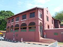
The Malaysia Architecture Museum (Malay: Muzium Seni Bina Malaysia) is a museum in Melaka City, Melaka, Malaysia.[1][2]
History
The museum building was originally built by the Dutch Empire in the 18th century during their occupation of Melaka as the residence and administration center of the Dutch officials. During the British Malaya period, the building was used as an administrative office. After the independence of Malaya in 1957, the building became the office of Melaka Water Board.[3] In 2000, the building was restored to its original shape by the department of Museum and Antiquities. The museum was opened in 2004 and it is administered under the Antiquity and Museum Association.[4][5]
Architecture

The museum was built with Dutch architectural style. The building consists of two floors, which is divided into:
- Ground floor
- Introduction
- Historical Development of Malaysian Architecture
- Architecture and Beliefs
- Upper floor
- The Typology
- Carvings and Motifs
- Tools and Technology
- Materials
Exhibitions
The museum exhibits various architectural materials and also the concept of it, such as from the Netherlands, China and Portugal.[4] It also displays various building models.[6]
Opening time
The museum is opened everyday from 9:00 a.m. to 5:00 p.m. free of charge.[3]
See also
References
- ↑ "Muzium Seni Bina". Pangea Guides.
- ↑ "Kontraktor tak mengaku salah tipu kurator muzium [METROTV]". 4 July 2017.
- 1 2 "Malaysia Architecture Museum - Melaka".
- 1 2 "Malaysia Architectural Museum - Department of Museums Malaysia". www.jmm.gov.my.
- ↑ "Muzium Senibina Malaysia – Melaka Cool". melakacool.com.
- ↑ "Architecture Museum of Malaysia - goMelaka". 3 July 2013.
| Wikimedia Commons has media related to Malaysia Architecture Museum. |
Coordinates: 2°11′33.8″N 102°14′54.8″E / 2.192722°N 102.248556°E