Maine-et-Loire
| Maine-et-Loire | |||
|---|---|---|---|
| Department | |||
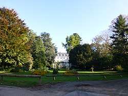 Prefecture gardens of the Maine-et-Loire department, in Angers | |||
| |||
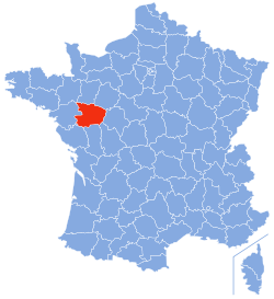 Location of Maine-et-Loire in France | |||
| Coordinates: 47°27′N 0°36′W / 47.450°N 0.600°WCoordinates: 47°27′N 0°36′W / 47.450°N 0.600°W | |||
| Country | France | ||
| Region | Pays de la Loire | ||
| Prefecture | Angers | ||
| Subprefectures |
Cholet Saumur Segré | ||
| Government | |||
| • President of the General Council | Christophe Béchu (UMP) | ||
| Area1 | |||
| • Total | 7,107 km2 (2,744 sq mi) | ||
| Population (2013) | |||
| • Total | 800,191 | ||
| • Rank | 27th | ||
| • Density | 110/km2 (290/sq mi) | ||
| Time zone | UTC+1 (CET) | ||
| • Summer (DST) | UTC+2 (CEST) | ||
| Department number | 49 | ||
| Arrondissements | 4 | ||
| Cantons | 21 | ||
| Communes | 183 | ||
| ^1 French Land Register data, which exclude estuaries, and lakes, ponds, and glaciers larger than 1 km2 | |||

Maine-et-Loire (French pronunciation: [mɛn.e.lwaʁ]) is a department of the Loire Valley in west-central France, in the Pays de la Loire region.[1]
History
- See also: Anjou and History of Maine-et-Loire
Maine-et-Loire is one of the original 83 departments created during the French Revolution on March 4, 1790. Originally it was called Mayenne-et-Loire, but its name was changed to Maine-et-Loire in 1791. It was created from most of the former province of Anjou. Its present name is drawn from the Maine and Loire Rivers, which meet within the department.
Geography
Maine-et-Loire is part of the current region of Pays-de-la-Loire and is surrounded by the departments of Ille-et-Vilaine, Mayenne, Sarthe, Indre-et-Loire, Vienne, Deux-Sèvres, Vendée, and Loire-Atlantique. The principal city is Angers.
It has a varied landscape, with forested ranges of hills in the south and north separated by the valley of the Loire. The highest point is Colline des Gardes at 210 m (690 ft).
The area has many navigable rivers such as the Loire, Sarthe, Mayenne, Loir, and Authion.
Demographics
The inhabitants of Maine-et-Loire have no official qualifier. They are sometimes known as Angevins, from the former province of Anjou, or Mainéligériens, from the name of the département.[2]
Tourism
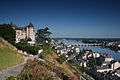
- Château de Montsoreau.[3][4]
- Royal Abbey of Fontevraud.
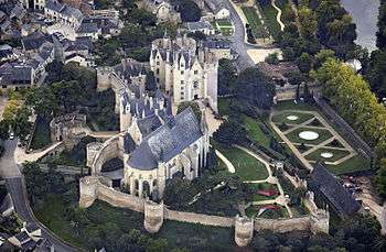
- Château de Brissac.
- Château de Saumur.
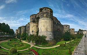
- Château d'Angers.
- Château de Brézé.
Anjou traditions
- The largest vineyard of the Loire Valley.
- The boule de fort, the traditional boules game in Anjou
Angers and around:
- The Angers castle and the Apocalypse Tapestry, the largest tapestry in the world.
- The Cointreau museum, in Saint-Barthélemy-d'Anjou
- The Château de Brissac, the tallest castle of the Loire Valley.
- The crooked spires in Baugé region.
Saumur and around:
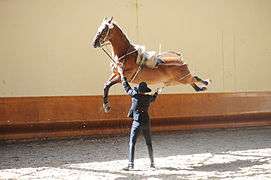
- The Cadre Noir, one of the most famous horsemanship school in the world.
- Montsoreau Flea Market is the largest Flea Market in the Loire Valley taking place every second Sunday of the month.[5][6][7]
- Château de Montsoreau-Museum of contemporary art, featuring the Philippe Méaille Collection, largest collection of works by the British conceptual artists, Art & Language.[8][9][10]
- The Royal Abbey of Fontevraud and the graves of the House of Plantagenet, including Richard I of England.
- The Tank museum of Saumur, which display the largest tank collection in France.
- Around Saumur, the largest concentration of troglodyte house in Europe.
Cholet and around:
- The textile museum of Cholet, and the creation of the famous red and white handkerchief.
- The Château de Touvois
- The Parc Oriental de Maulévrier, the largest Japanese garden of France
Segré and around:
- The fortified city of Pouancé and its medieval castle.
- The Blue Mine, a slate mine, with a funicular which goes 130 meters under the surface.
- The National stud of Le Lion-d'Angers, which host every year Le Mondial du Lion
- The Château de Challain-la-Potherie

.jpg)
See also
References
- ↑ Centre, UNESCO World Heritage. "The Loire Valley between Sully-sur-Loire and Chalonnes". whc.unesco.org. Retrieved 2018-02-12.
- ↑ "Vous voulez vous appeler Angevin ou Mainoligérien ? Dernier jour pour voter !". ouest-france.fr. Ouest France. Retrieved 30 July 2014.
- ↑ "Château de Montsoreau-Contemporary Art Museum - Les Châteaux de la Loire". Les Châteaux de la Loire. Retrieved 2018-10-06.
- ↑ "Visit Chateau de Montsoreau-Museum of contemporary art on your trip to Montsoreau". www.inspirock.com. Retrieved 2018-10-06.
- ↑ "Practical Information". Château de Montsoreau-Museum of Contemporary Art. Retrieved 2018-09-15.
- ↑ "Snapshots of the Loire The Montsoreau flea market". TVMONDE. Retrieved 2018-09-17.
- ↑ "Discover the World's 500 Best Flea Markets". Fleamapket. Retrieved 2018-09-17.
- ↑ "Largest Art & Language Collection Finds Home - artnet News". artnet News. 2015-06-23. Retrieved 2018-02-12.
- ↑ "MACBA banks on History". Artinamericamagazine.com. 2011.
- ↑ "Art & Language Uncompleted". macba.cat. 2014.
External links
| Wikimedia Commons has media related to Maine-et-Loire. |
- (in French) Prefecture website
- (in French) General council website
- (in English) Anjou Tourism Board website
