Maine State Route 187
| ||||
|---|---|---|---|---|
 | ||||
| Route information | ||||
| Maintained by MaineDOT | ||||
| Length | 22.87 mi[1] (36.81 km) | |||
| Major junctions | ||||
| West end |
| |||
| East end |
| |||
| Location | ||||
| Counties | Washington | |||
| Highway system | ||||
| ||||

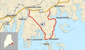
State Route 187 (SR 187) is a 22.83-mile-long (36.74 km) V-shaped state highway in Maine that connects to U.S. Route 1 (US 1) at both ends; in Columbia Falls (western) and Jonesboro (eastern). SR 187 serves as the thorough route to Jonesport.
Major junctions
The entire route is in Washington County.
| Location | mi[1] | km | Destinations | Notes | |
|---|---|---|---|---|---|
| Columbia Falls | 0.00 | 0.00 | |||
| Jonesboro | 22.87 | 36.81 | |||
| 1.000 mi = 1.609 km; 1.000 km = 0.621 mi | |||||
References
- 1 2 "Maine DOT Map Viewer". Maine Office of GIS. Retrieved August 30, 2017.
See also

External links
This article is issued from
Wikipedia.
The text is licensed under Creative Commons - Attribution - Sharealike.
Additional terms may apply for the media files.