Maine State Route 186
| ||||
|---|---|---|---|---|
 | ||||
| Route information | ||||
| Maintained by MaineDOT | ||||
| Length | 16.00 mi[1] (25.75 km) | |||
| Existed | 1925 – present | |||
| Major junctions | ||||
| West end |
| |||
|
| ||||
| East end |
| |||
| Location | ||||
| Counties | Hancock | |||
| Highway system | ||||
| ||||

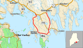
State Route 186 (SR 186) is a sixteen-mile-long (26 km) state highway in south central Maine. The highway serves the town of Gouldsboro, running in a half-loop from U.S. Route 1 (US 1), south and east along the southern coast to Winter Harbor near Frenchman Bay, and then returning to US 1.[2]
Major junctions
The entire route is in Hancock County.
| Location | mi[1] | km | Destinations | Notes | |
|---|---|---|---|---|---|
| Gouldsboro | 0.00 | 0.00 | |||
| 10.82 | 17.41 | Western end of SR 195 concurrency | |||
| 10.98 | 17.67 | Eastern end of SR 195 concurrency | |||
| 16.00 | 25.75 | ||||
1.000 mi = 1.609 km; 1.000 km = 0.621 mi
| |||||
References
- 1 2 "Maine DOT Map Viewer". Maine Office of GIS. Retrieved August 29, 2017.
- ↑ Google (August 29, 2017). "Maine State Route 186" (Map). Google Maps. Google. Retrieved August 29, 2017.
External links
This article is issued from
Wikipedia.
The text is licensed under Creative Commons - Attribution - Sharealike.
Additional terms may apply for the media files.