Maine State Route 136
| ||||
|---|---|---|---|---|
 | ||||
| Route information | ||||
| Maintained by MaineDOT | ||||
| Length | 19.07 mi[1] (30.69 km) | |||
| Major junctions | ||||
| South end |
| |||
| North end |
| |||
| Location | ||||
| Counties | Cumberland, Androscoggin | |||
| Highway system | ||||
| ||||

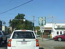
Maine State Route 136 in Auburn
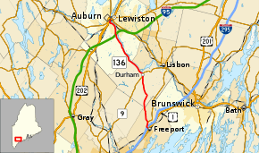
State Route 136 (SR 136) is a numbered state highway in Maine, United States. It begins with SR 125 at the junction of U.S. Route 1 (US 1) in Freeport, and travels to Auburn. Although it is only approximately 19 miles (31 km) long, it connects three major Maine commerce areas (Lewiston, Auburn, and Freeport as well as points south).[2]
Major junctions
| County | Location | mi[1] | km | Destinations | Notes |
|---|---|---|---|---|---|
| Cumberland | Freeport | 0.00 | 0.00 | Southern end of SR 125 concurrency | |
| 0.34– 0.55 | 0.55– 0.89 | Exit 22 (I-295) | |||
| 1.27 | 2.04 | Northern end of SR 125 concurrency | |||
| Androscoggin | Durham | 8.56 | 13.78 | Southern end of SR 9 concurrency | |
| 8.95 | 14.40 | Northern end of SR 9 concurrency | |||
| Auburn | 19.07 | 30.69 | |||
1.000 mi = 1.609 km; 1.000 km = 0.621 mi
| |||||
References
- 1 2 "Maine DOT Map Viewer". Maine Office of GIS. Retrieved August 2, 2017.
- ↑ Google (August 2, 2017). "Maine State Route 136" (Map). Google Maps. Google. Retrieved August 2, 2017.
External links
This article is issued from
Wikipedia.
The text is licensed under Creative Commons - Attribution - Sharealike.
Additional terms may apply for the media files.