Blankenfelde-Mahlow
| Blankenfelde-Mahlow | |
|---|---|
|
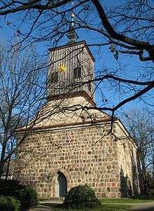
Church in Blankenfelde | |
 Blankenfelde-Mahlow Location of Blankenfelde-Mahlow within Teltow-Fläming district | |
| Coordinates: 52°21′00″N 13°24′00″E / 52.35000°N 13.40000°ECoordinates: 52°21′00″N 13°24′00″E / 52.35000°N 13.40000°E | |
| Country | Germany |
| State | Brandenburg |
| District | Teltow-Fläming |
| Government | |
| • Mayor | Ortwin Baier (SPD) |
| Area | |
| • Total | 54.89 km2 (21.19 sq mi) |
| Elevation | 43 m (141 ft) |
| Population (2017-12-31)[1] | |
| • Total | 27,378 |
| • Density | 500/km2 (1,300/sq mi) |
| Time zone | CET/CEST (UTC+1/+2) |
| Postal codes | 15827, 15831 |
| Dialling codes | 03379 |
| Vehicle registration | TF |
| Website | www.blankenfelde-mahlow.de |
Blankenfelde-Mahlow is a municipality in the Teltow-Fläming district of Brandenburg, Germany. It is situated approximately 3 kilometres (2 miles) south of Berlin.
History
Church in Mahlow
The municipality shared its borders with the former West Berlin, and so during the period 1961-1990 it was separated.
Demography
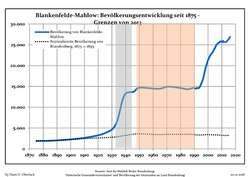 Development of population since 1875 within the current Boundaries (Blue Line: Population; Dotted Line: Comparison to Population development in Brandenburg state; Grey Background: Time of Nazi Germany; Red Background: Time of communist East Germany)
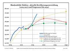 Recent Population Development and Projections (Population Development before Census 2011 (blue line); Recent Population Development according to the Census in Germany in 2011 (blue bordered line); Projection by the Brandenburg state for 2005-2030 (yellow line); Projection by the Brandenburg state for 2014-2030 (red line); Projection by the Bertelsmann Foundation for 2012-2030 (green line)
| Blankenfelde-Mahlow: Population development within the current boundaries (2017)[2] | ||||||||||||||||||||||||||||||||||||||||||||||||||||||||||||||||||||||||||||||||||||||||||||||||||||||||||||||||||||||||||||||||||||||
|---|---|---|---|---|---|---|---|---|---|---|---|---|---|---|---|---|---|---|---|---|---|---|---|---|---|---|---|---|---|---|---|---|---|---|---|---|---|---|---|---|---|---|---|---|---|---|---|---|---|---|---|---|---|---|---|---|---|---|---|---|---|---|---|---|---|---|---|---|---|---|---|---|---|---|---|---|---|---|---|---|---|---|---|---|---|---|---|---|---|---|---|---|---|---|---|---|---|---|---|---|---|---|---|---|---|---|---|---|---|---|---|---|---|---|---|---|---|---|---|---|---|---|---|---|---|---|---|---|---|---|---|---|---|---|
|
|
| ||||||||||||||||||||||||||||||||||||||||||||||||||||||||||||||||||||||||||||||||||||||||||||||||||||||||||||||||||||||||||||||||||||
See also
Sons and daughters of the community
- Manfred Görg (1938-2012), Catholic theologian and Egyptologist, was born in Blankenfelde
- Hans-Joachim Hacker (born 1949), politician (SPD)
- Jan-Michael Feustel (1951-2009), art historian and author
- Dietmar Klemt, politician (SPD), mayor and official director 1992-2003
References
- ↑ "Bevölkerung im Land Brandenburg nach amtsfreien Gemeinden, Ämtern und Gemeinden 31. Dezember 2017 (Fortgeschriebene amtliche Einwohnerzahlen auf Grundlage des Zensus 2011)". Amt für Statistik Berlin-Brandenburg (in German). 2018.
- ↑ Detailed data sources are to be found in the Wikimedia Commons.Population Projection Brandenburg at Wikimedia Commons
Towns and municipalities in Teltow-Fläming | ||
|---|---|---|
| Authority control |
|---|
This article is issued from
Wikipedia.
The text is licensed under Creative Commons - Attribution - Sharealike.
Additional terms may apply for the media files.