Mafia Island
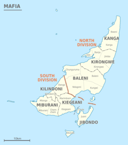 Administrative map (divisions, wards, and villages) | |
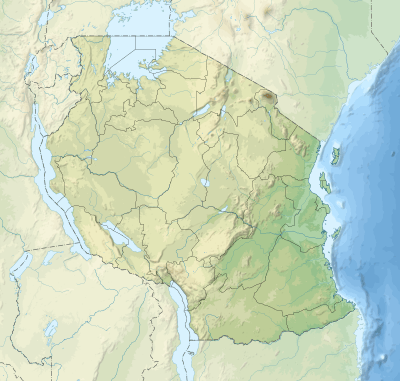 Mafia Island Location of Mafia Island 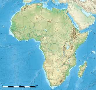 Mafia Island Mafia Island (Africa)  Mafia Island Mafia Island (Earth) | |
| Geography | |
|---|---|
| Coordinates | 7°51′S 39°47′E / 7.850°S 39.783°ECoordinates: 7°51′S 39°47′E / 7.850°S 39.783°E |
| Archipelago | Tanzania Mainland Archipelago |
| Area | 435 km2 (168 sq mi) |
| Length | 49 km (30.4 mi) |
| Width | 17 km (10.6 mi) |
| Highest elevation | 53 m (174 ft) |
| Region | Tanzania |
| Largest settlement | Kilindoni (pop. 11,696) |
| Demographics | |
| Population | 46,850 (2012) |
| Additional information | |
| Time zone | |
| Official website | Country website |
Mafia Island ("Chole Shamba") is not part of the Tanzanian Zanzibar Archipelago, which is formed of Unguja, Pemba, Mnemba and Latham Island. As one of the six districts of the Pwani Region, Mafia Island is governed from the mainland, not from the semi-autonomous region of Zanzibar, of which it has never been considered to be a part politically.
According to the 2002 Tanzania census, the population of the Mafia District was 40,801.[1] The economy is based on fishing, subsistence agriculture and the market in Kilindoni. The island attracts some tourists, mainly adventure scuba divers, game fishermen, and people wanting relaxation.
Geography
The Mafia archipelago consists of one large island (394 km²) and several smaller ones. Some of the smaller ones are inhabited, such as Chole Island (2 km²), with a population of 1415. Chole Bay, Mafia's protected deep-water anchorage and original harbour, is studded with islands, sandbanks and beaches. The main town is Kilindoni. The stretch of water between the deltas of the Rufiji River and the island is called Mafia Channel.
Climate
Mafia island has a tropical climate. This climate is classified as "Aw" by the Köppen-Geiger system. The average temperature in town of Kilindoni is 26.7°C (78°F). The average annual rainfall is 1,705 mm. The monthly average temperatures are usually between 24.8 - 28.3°C (77°F - 83°F). There is one major rain season, with most rainfall coming between March and May. Dry season spans between July to October.
| Climate data for Kilindoni | |||||||||||||
|---|---|---|---|---|---|---|---|---|---|---|---|---|---|
| Month | Jan | Feb | Mar | Apr | May | Jun | Jul | Aug | Sep | Oct | Nov | Dec | Year |
| Average high °C (°F) | 31.3 (88.3) |
31.6 (88.9) |
31.3 (88.3) |
29.9 (85.8) |
29.3 (84.7) |
28.3 (82.9) |
27.5 (81.5) |
28.2 (82.8) |
29.3 (84.7) |
30.3 (86.5) |
30.6 (87.1) |
31.1 (88) |
29.9 (85.8) |
| Daily mean °C (°F) | 28.3 (82.9) |
28.3 (82.9) |
28.1 (82.6) |
27.0 (80.6) |
26.4 (79.5) |
25.4 (77.7) |
24.8 (76.6) |
25.0 (77) |
25.7 (78.3) |
26.8 (80.2) |
27.2 (81) |
27.8 (82) |
26.7 (80.1) |
| Average low °C (°F) | 25.3 (77.5) |
25.1 (77.2) |
25.0 (77) |
24.2 (75.6) |
23.5 (74.3) |
22.6 (72.7) |
22.1 (71.8) |
21.9 (71.4) |
22.2 (72) |
23.3 (73.9) |
23.9 (75) |
24.6 (76.3) |
23.6 (74.5) |
| Average precipitation mm (inches) | 134 (5.28) |
98 (3.86) |
234 (9.21) |
482 (18.98) |
260 (10.24) |
80 (3.15) |
49 (1.93) |
25 (0.98) |
22 (0.87) |
35 (1.38) |
102 (4.02) |
184 (7.24) |
1,705 (67.13) |
| Source: Climate-Data.ORG[2] | |||||||||||||
History
Mafia Island's history goes back to the 8th century. The island once played a major role in ancient trade between the people of East Asia and East Africa. It was a regular stop for Arab boats. On the tiny island of Chole Mjini, just offshore in Chole Bay, once stood a settlement that constituted one of the most important towns controlling trade from the silver mines of Eastern Zimbabwe, which reached the town via the old ports of Kilwa and Michangani.
In the mid-1820s, the town of Kua on Juani Island was attacked by Sakalava cannibals arriving from Madagascar with 80 canoes, who ate many of the locals and took the rest into slavery.
Under a treaty of 1890, Germany took control of Mafia and constructed the buildings still evident on Chole. Germany paid Sultan Sayyid Ali bin Said al-Said of Zanzibar M 4 million for both the island and part of the mainland coast. On January 12, 1915, Mafia was taken by British troops as a base for the air and sea assault on the light cruiser Königsberg.
The name "Mafia" derives from the Arabic morfiyeh, meaning "group" or "archipelago", or from the Swahili mahali pa afya, meaning "a healthy dwelling-place".
In 1995 Mafia Island had financial help from the WWF to make a natural marine wildlife centre which led to establishment of the first Marine Park in Tanzania. The organization continued to provide support to the Island under Rufiji-Mafia-Kilwa (RUMAKI)[3] seascape project to improve socio-economic well-being of the communities through the sustainable, participatory and equitable utilization and protection of their natural resources. Under the current EU-WWF Fisheries Co-management Project,[4] the organization aims at building effective long-term fisheries co-management through establishment of 10 Beach Management Units and to continue supporting Village Community Banks (VICOBA) in the Island to generate optimal, sustainable and equitable livelihood benefits, and which provide a source of lesson-learning for other coastal communities. The WWF Mafia office is under three technical staff - Paul Kugopya (Mafia Fisheries Co-management Officer), Marko Gideon[5] (EU-WWF Fisheries Co-management Project Communication/Awareness Officer) and Renatus Rwamugira (Project Accountant for Mafia).
Tanzania's first multi-user marine park at Mafia Island was established in 1995 following management recommendations and data from surveys conducted by the Society for Environmental Exploration.[6]
In August 2016, a diver, Alan Sutton, from Seaunseen, who had originally been looking for the remains of an old fort rumoured to have been washed away to sea, instead came across the remains of a wall stretching almost 4km off Mafia Island. The discovery was detailed in a blog post by Sutton, with images showing remnants of the wall.[7]
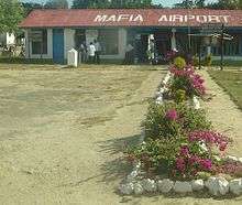
Transport

Airport
The island can be reached from Dar es Salaam by flights operated by Auric Air[8] and Coastal Aviation.[9]
Administration
The Mafia District is administratively divided into seven wards, listed with area and population:[10]
| Ward | Area km² | Population 2002 | Villages |
|---|---|---|---|
| Baleni | 132.1 | 9,137 | Baleni, Kungwi, Ndagoni, Chunguruma |
| Jibondo | 21.9 | 3,405 | Jibondo, Chole, Juani |
| Kanga | 52.7 | 3,317 | Kanga, Bweni |
| Kilindoni | 36.8 | 11,696 | Kilindoni, Dongo |
| Kirongwe | 77.0 | 5,260 | Kirongwe, Jimbo, Banja, Jojo |
| Kiegeani | 40.3 | 3,379 | Kiegani, Marimbani |
| Mibulani | 52.3 | 4,363 | Miburani, Mlongo, Chemchem |
| Mafia Island | 413 | 40,801 | 20 villages |
See also
Gallery
.jpg) A map of Tanzania showing Mafia Island
A map of Tanzania showing Mafia Island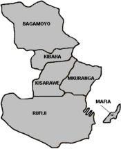 Districts of Pwani Region showing Mafia District
 Historical nautical chart
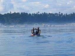 Harbour of Mafia Island as seen from a departing boat
Sources
References
- ↑ "Archived copy". Archived from the original on 2007-06-10. Retrieved 2016-02-03.
- ↑ "Kilindoni". Retrieved July 26, 2017.
- ↑ "WWF - Rufiji-Mafia-Kilwa Seascape Programme, Tanzania". panda.org.
- ↑ "European Union". europa.eu.
- ↑ Mark Shekalaghe. "Tembelea Tanzania". safiritz.blogspot.com.
- ↑ "Internet Archive Wayback Machine". 12 October 2007. Archived from the original on 12 October 2007.
- ↑ Osborne, Hannah (13 May 2016). "Diver in Tanzania discovers ancient city submerged beneath the sea off Mafia Island".
- ↑ "Auric Air". Auric Air Services Ltd. March 30, 2012. Retrieved March 30, 2012.
- ↑ "Coastal Aviation". Coastal Aviation. August 5, 2017.
- ↑ Administrator. "Policies". mca-t.go.tz. Archived from the original on 2012-04-25.
- Chami, F. A. 1999. “The Early Iron Age on Mafia island and its relationship with the mainland.” Azania Vol. XXXIV 1999, pp. 1–10.
- Chami, Felix A. 2002. “The Graeco-Romans and Paanchea/Azania: sailing in the Erythraean Sea” by Felix A. Chami. From: Red Sea Trade and Travel. The British Museum. Organised by The Society for Arabian Studies. Downloaded on 20 July 2003 from thebritishmuseum.ac.uk (archive)
External links
| Wikimedia Commons has media related to Mafia Island. |
| Wikivoyage has a travel guide for Mafia Island. |