Mae Wang District
| Mae Wang แม่วาง | |
|---|---|
| District | |
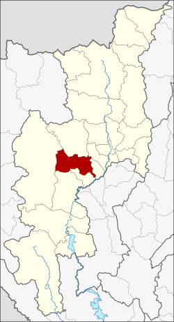 District location in Chiang Mai Province | |
| Coordinates: 18°36′45″N 98°46′30″E / 18.61250°N 98.77500°ECoordinates: 18°36′45″N 98°46′30″E / 18.61250°N 98.77500°E | |
| Country | Thailand |
| Province | Chiang Mai |
| Seat | Ban Kat |
| Area | |
| • Total | 601.680 km2 (232.310 sq mi) |
| Population (2005) | |
| • Total | 30,871 |
| • Density | 51.3/km2 (133/sq mi) |
| Time zone | UTC+7 (ICT) |
| Postal code | 57110 |
| Geocode | 5022 |
Mae Wang (Thai: แม่วาง, pronounced [mɛ̂ː wāːŋ]) is a district (amphoe) in the central part of Chiang Mai Province in northern Thailand.
Geography

Neighboring districts are (from the south clockwise) Doi Lo, Chom Thong, Mae Chaem, Samoeng, Hang Dong and San Pa Tong of Chiang Mai Province.
Flora
Sapria Himalayana is a rare holo-parasitic flower related to Rafflesia. This particular specimen was found in Mae Wang District.
History
The minor district (king amphoe) was established on 1 April 1990, when the four tambons Ban Kat, Thung Pi, Thung Ruang Thong, and Mae Win were split off from San Pa Tong District.[1] On 7 September 1995 it was upgraded to a full district.[2]
Administration
The district is divided into five sub-districts (tambon), which are further subdivided into 62 villages (muban). Ban Kat is a township (thesaban tambon) which covers parts of tambons Ban Kat and Don Pao. There are a further five tambon administrative organizations (TAO).
| No. | Name | Thai name | Villages | Pop. | |
|---|---|---|---|---|---|
| 1. | Ban Kat | บ้านกาด | 13 | 5,544 | |
| 2. | Thung Pi | ทุ่งปี้ | 12 | 4,602 | |
| 3. | Thung Ruang Thong | ทุ่งรวงทอง | 8 | 2,650 | |
| 4. | Mae Win | แม่วิน | 19 | 10,879 | |
| 5. | Don Pao | ดอนเปา | 10 | 7,196 |
References
- ↑ ประกาศกระทรวงมหาดไทย เรื่อง แบ่งเขตท้องที่อำเภอสันป่าตอง จังหวัดเชียงใหม่ ตั้งเป็นกิ่งอำเภอแม่วาง (PDF). Royal Gazette (in Thai). 107 (25 ง): 1349. February 13, 1990.
- ↑ พระราชกฤษฎีกาตั้งอำเภอด่านมะขามเตี้ย อำเภอแก่งหางแมว อำเภอภักดีชุมพล อำเภอเวียงแก่น อำเภอแม่วาง อำเภอถ้ำพรรณรา อำเภอบ่อเกลือ อำเภอโนนสุวรรณ อำเภอห้วยราช อำเภอแม่ลาน อำเภอบางแก้ว อำเภอป่าพะยอม อำเภอหนองม่วงไข่ อำเภอยางสีสุราช อำเภอจังหาร อำเภอบ้านธิ อำเภอภูสิงห์ อำเภอบางกล่ำ อำเภอวังม่วง และอำเภอนายูง พ.ศ. ๒๕๓๘ (PDF). Royal Gazette (in Thai). 112 (32 ก): 1–3. August 8, 1995.