Mae Ai District
| Mae Ai แม่อาย | |
|---|---|
| District | |
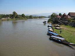 The Kok River, Mae Ai | |
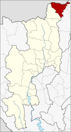 District location in Chiang Mai Province | |
| Coordinates: 20°1′53″N 99°17′13″E / 20.03139°N 99.28694°ECoordinates: 20°1′53″N 99°17′13″E / 20.03139°N 99.28694°E | |
| Country | Thailand |
| Province | Chiang Mai |
| Seat | Mae Ai |
| Tambon | 7 |
| Muban | 99 |
| District established | 1967 |
| Area | |
| • Total | 736.701 km2 (284.442 sq mi) |
| Population (2014) | |
| • Total | 73,537 |
| • Density | 104.9/km2 (272/sq mi) |
| Time zone | UTC+7 (ICT) |
| Postal code | 50280 |
| Geocode | 5010 |
Mae Ai (Thai: แม่อาย, pronounced [mɛ̂ː ʔāːj]) is the northernmost district (amphoe) of Chiang Mai Province, northern Thailand.
History
The minor district (king amphoe) Mae Ai was created on 15 August 1967, when the three tambons Mae Ai, Mae Sao, and Mae Na Wang were separated from Fang District.[1] It was upgraded to a full district on 28 June 1973.[2]
Geography
Neighboring districts are (from the southwest clockwise) Fang of Chiang Mai Province, Shan State of Myanmar, Mae Fa Luang, Mueang Chiang Rai, and Mae Suai of Chiang Rai Province.
The important rivers are the Kok and Fang Rivers.
Administration
Central administration
Mae Ai is divided into seven sub-districts (tambon), which are further divided into 93 administrative villages (muban).
| No. | Name | Thai | Villages | Pop.[3] |
|---|---|---|---|---|
| 1. | Mae Ai | แม่อาย | 13 | 9,699 |
| 2. | Mae Sao | แม่สาว | 16 | 12,020 |
| 3. | San Ton Mue | สันต้นหมื้อ | 12 | 6,348 |
| 4. | Mae Na Wang | แม่นาวาง | 17 | 14,206 |
| 5. | Tha Ton | ท่าตอน | 15 | 19,902 |
| 6. | Ban Luang | บ้านหลวง | 10 | 7,215 |
| 7. | Malika | มะลิกา | 10 | 4,285 |
Local administration
There is one sub-district municipality (thesaban tambon) in the district:
- Mae Ai (Thai: เทศบาลตำบลแม่อาย) consisting of parts of the sub-districts Mae Ai, Malika.
There are six sub-district administrative organizations (SAO) in the district:
- Doi Lang (Thai: องค์การบริหารส่วนตำบลดอยลาง) consisting of parts of sub-districts Mae Ai and Malika.
- Mae Sao (Thai: องค์การบริหารส่วนตำบลแม่สาว) consisting of sub-district Mae Sao.
- San Ton Mue (Thai: องค์การบริหารส่วนตำบลสันต้นหมื้อ) consisting of sub-district San Ton Mue.
- Mae Na Wang (Thai: องค์การบริหารส่วนตำบลแม่นาวาง) consisting of sub-district Mae Na Wang.
- Tha Ton (Thai: องค์การบริหารส่วนตำบลท่าตอน) consisting of sub-district Tha Ton.
- Ban Luang (Thai: องค์การบริหารส่วนตำบลบ้านหลวง) consisting of th sub-district Ban Luang.
References
- ↑ ประกาศกระทรวงมหาดไทย เรื่อง แบ่งท้องที่ตั้งเป็นกิ่งอำเภอ (PDF). Royal Gazette (in Thai). 84 (80 ง): 2397. August 29, 1967.
- ↑ พระราชกฤษฎีกาตั้งอำเภอเขาพนม อำเภอสนามชัยเขต อำเภอแม่อาย อำเภอขามสะแกแสง อำเภอเก้าเลี้ยว อำเภอโพธิ์ประทับช้าง อำเภอหนองพอก อำเภอละอุ่น อำเภอทุ่งหว้า และอำเภอศรีธาตุ พ.ศ. ๒๕๑๖ (PDF). Royal Gazette (in Thai). 90 (75 ก special): 32–36. June 28, 1973.
- ↑ "Population statistics 2014" (in Thai). Department of Provincial Administration. Retrieved 2015-09-17.