Mae Chan District
| Mae Chan แม่จัน | |
|---|---|
| Amphoe | |
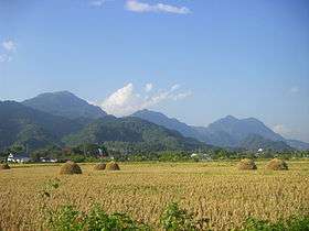 Doi Nang Non, the "Mountain of the Sleeping Lady" | |
 Amphoe location in Chiang Rai Province | |
| Coordinates: 20°8′48″N 99°51′12″E / 20.14667°N 99.85333°ECoordinates: 20°8′48″N 99°51′12″E / 20.14667°N 99.85333°E | |
| Country | Thailand |
| Province | Chiang Rai |
| Seat | Mae Chan |
| Tambon | 8 |
| Muban | 139 |
| Area | |
| • Total | 791.0 km2 (305.4 sq mi) |
| Population (2015) | |
| • Total | 108,182 |
| • Density | 129.7/km2 (336/sq mi) |
| Time zone | UTC+7 (ICT) |
| Postal code | 57110 |
| Geocode | 5707 |
Mae Chan (Thai: แม่จัน, pronounced [mɛ̂ː t͡ɕān]) is a district (amphoe) in the northern part of Chiang Rai Province, northern Thailand.
Geography

Neighboring districts are (from the north clockwise) Mae Sai, Chiang Saen, Doi Luang, Mueang Chiang Rai and Mae Fa Luang of Chiang Rai Province.
Doi Nang Non, the "Mountain of the Sleeping Lady", is part of the Daen Lao Range and is one of the main geographic features of Mae Chan District.
History
The district was created as the successor of Mueang Chiang Saen. The original center of the mueang later became part of the minor district Chiang Saen Luang, so in 1939 this minor district was renamed to Chiang Saen, while the district Chiang Saen itself was renamed to Mae Chan.[1]
Administration
Central administration
The district Mae Chan is subdivided into 11 subdistricts (Tambon), which are further subdivided into 139 administrative villages (Muban).
| No. | Name | Thai | Villages | Pop.[2] |
|---|---|---|---|---|
| 1. | Mae Chan | แม่จัน | 14 | 11,084 |
| 2. | Chan Chwa | จันจว้า | 11 | 7,151 |
| 3. | Mae Kham | แม่คำ | 14 | 10,544 |
| 4. | Pa Sang | ป่าซาง | 15 | 11,763 |
| 5. | San Sai | สันทราย | 9 | 4,974 |
| 6. | Tha Khao Plueak | ท่าข้าวเปลือก | 14 | 8,196 |
| 8. | Pa Tueng | ป่าตึง | 20 | 26,197 |
| 10. | Mae Rai | แม่ไร่ | 9 | 10,213 |
| 11. | Si Kham | ศรีค้ำ | 11 | 6,118 |
| 12. | Chan Chwa Tai | จันจว้าใต้ | 12 | 8,013 |
| 13. | Chom Sawan | จอมสวรรค์ | 10 | 3,930 |
Missing numbers are tambon which now form Doi Luang District.
Local administration
There are eight sub-district municipalities (thesaban tambon) in the district:
- Chan Chwa (Thai: เทศบาลตำบลจันจว้า) consisting of the complete sub-district Chan Chwa and Chan Chwa Tai.
- Mae Kham (Thai: เทศบาลตำบลแม่คำ) consisting of parts of the sub-district Mae Kham.
- Mae Chan (Thai: เทศบาลตำบลแม่จัน) consisting of parts of the sub-district Mae Chan.
- San Sai (Thai: เทศบาลตำบลสันทราย) consisting of parts of the sub-district San Sai.
- Pa Sang (Thai: เทศบาลตำบลป่าซาง) consisting of the complete sub-district Pa Sang.
- Sai Nam Kham (Thai: เทศบาลตำบลสายน้ำคำ) consisting of parts of the sub-district Mae Kham.
- Tha Khao Plueak (Thai: เทศบาลตำบลท่าข้าวเปลือก) consisting of the complete sub-district Tha Khao Plueak.
- Mae Rai (Thai: เทศบาลตำบลแม่ไร่) consisting of the complete sub-district Mae Rai.
There are five sub-district administrative organizations (SAO) in the district:
- Mae Chan (Thai: องค์การบริหารส่วนตำบลแม่จัน) consisting of parts of the sub-district Mae Chan.
- San Sai (Thai: องค์การบริหารส่วนตำบลสันทราย) consisting of parts of the sub-district San Sai.
- Pa Tueng (Thai: องค์การบริหารส่วนตำบลป่าตึง) consisting of the complete sub-district Pa Tueng.
- Si Kham (Thai: องค์การบริหารส่วนตำบลศรีค้ำ) consisting of the complete sub-district Si Kham.
- Chom Sawan (Thai: องค์การบริหารส่วนตำบลจอมสวรรค์) consisting of the complete sub-district Chom Sawan.
References
- ↑ พระราชกฤษฎีกาเปลี่ยนนามอำเภอ กิ่งอำเภอ และตำบลบางแห่ง พุทธศักราช ๒๔๘๒ (PDF). Royal Gazette (in Thai). 56 (0 ก): 354–364. April 17, 1939.
- ↑ "Population statistics 2015" (in Thai). Department of Provincial Administration. Retrieved 2016-06-09.
External links

- amphoe.com
Chiang Rai | ||
|---|---|---|
| Main article |  | |
| Capital city | ||
| Districts (amphoe) | ||
| Related topics | ||