Madre de Dios River
| Madre de Dios River | |
 Madre de Dios near Boca Manú town, Peru | |
| Countries | Bolivia, Peru |
|---|---|
| Source | |
| - location | Cordillera Vilcanota, Peru |
| Mouth | Beni River |
| - location | Riberalta, Beni, Bolivia |
| Length | 1,060 km (659 mi) [1] |
| Discharge | |
| - average | 6,400 m3/s (226,014 cu ft/s) |
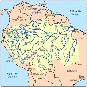 The Amazon Basin with the Madre de Dios River highlighted | |
The Madre de Dios River (Spanish pronunciation: [ˈmaðɾe ðe ðjos]), homonymous to the Peruvian region it runs through. On Bolivian territory it is an affluent to Beni River, close to the town of Riberalta, which later joins with the Mamore River to become the Madeira River after the confluence. The Madeira is a tributary to the Amazon River.
The Madre de Dios is an important waterway for the department of Madre de Dios, particularly Puerto Maldonado, the largest town in the area, and the capital of the department. Mango farming and gold mining are among the many industries on its beaches. Other important industries the Madre de Dios provides are selective logging and farming, both of which are serious environmental problems. Along the length of the river there are several national parks and reserves, notably Tambopata-Candamo National Park, Manú National Park (also known as Manú Biosphere Reserve) and Bahuaja-Sonene National Park.
Hydrography
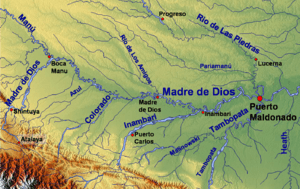
The Madre de Dios serves as the largest watershed in the area, as part of the vast Amazon River watershed. The river's main tributaries include on the right: Chivile, Azul, Blanco, Inambari, Tambopata and Colorado rivers and from the left: Los Amigos, Manú, and Las Piedras.[2]

References
- ↑ Ziesler, R.; Ardizzone, G.D. (1979). "Amazon River System". The Inland waters of Latin America. Food and Agriculture Organization of the United Nations. ISBN 92-5-000780-9. Archived from the original on 21 October 2013.
- ↑ Evaluacion Ambiental Territorial en la Zona Aurifera de Madre de Dios Archived 2008-12-17 at the Wayback Machine., 4. Climatología E Hidrologia Archived 2008-09-13 at the Wayback Machine. {es} Ministry of Energy and Mines, Peruvian Government, December 1997.