Tambopata National Reserve
| Tambopata National Reserve | |
|---|---|
|
IUCN category VI (protected area with sustainable use of natural resources) | |
 | |
| Location |
Madre de Dios Region, Tambopata Province |
| Nearest city | Puerto Maldonado |
| Coordinates | 12°55′14″S 69°16′55″W / 12.92056°S 69.28194°WCoordinates: 12°55′14″S 69°16′55″W / 12.92056°S 69.28194°W |
| Area | 274,690 hectares (1,060.6 sq mi) |
| Established | 04 September 2000 |
| Governing body | SERNANP |
Tambopata National Reserve (Spanish: Reserva Nacional Tambopata) is a nature reserve in the Peruvian Amazon Basin south of the Madre de Dios River in Tambopata Province's Inambari and Tambopata districts. It was created on January 26, 1990, to protect the forests adjacent to the rivers Heath and Tambopata that have two important ecosystems and are noted for its biodiversity, representing native flora and fauna with over 1700 species (comprising 127 families and 622 genera) of plants,[1] 103 species of mammals, 1300 species of butterflies and 90 species of amphibians.
The reserve is located across the regions of Madre de Dios and Puno:
- Tambopata is the 40% of the reserve in the department of Madre de Dios.
- Carabaya and Sandia are the 60% of the reserve in the department of Puno.[2]
Access is from Puerto Maldonado, where one can get to the preserve via the Tambopata River; or by car via the Puerto Maldonado–Cuzco Road (kilometer 30).[2]
Geography
It has a surface area of 1,478,942 hectares (3,654,550 acres).
The Sandoval Lake is located in this area. There is also a circuit of canoeing which is considered one of the most exciting and beautiful circuits of Peru.
The protected area features eight life zones: subtropical humid forest, tropical humid forest, subtropical high-humidity forest, subtropical high-humidity foothills cloud forest, subtropical rainforest, tropical cloud forest foothills, subtropical lower foothills cloud forest and semi-flooded subtropical cloud forest.
Average annual temperature is 26 °C, ranging from 10–38 °C; with average annual rainfall of 1600–2400 mm. Rainfall in the protected area is typical of most areas in the Peruvian Amazon. The climate is humid and (3000 mm and 25 °C on average), sub-level humidity and semi-warm (1700 mm and 26 °C on average), high-level semi-warm (4000 mm and 23 °C).[3]
History
A conservation process in the Tambopata Province (Madre de Dios) was initiated in Tambopata, where a group of naturalists and biologists proposed the conservation of 10,000 hectares of rainforests in the middle Tambopata River (January 3, 1977). This was established as "Zona Reservada Tambopata" (ZRT), in the territory of the traditional tribe Ese'eja. It was created for the conservation of the Amazon forest and for scientific research, as well as for tourism. In July 1977, the government had an arrangement with the Peruvian Safaris, owner of Explorer's Inn. This operator got an agreement for only five years. Differently, in 1983, the Santuario Nacional Pampas Del Heath (SNPH) was established, with a surface area of 105.957 hectares (261.83 acres). The purpose was to protect the unique territory of Sabana Húmeda Tropical in Peru.
By the 1986s, a Peruvian conservation NGO Selva Sur (ACSS)((now Peru Verde)) and a senior Wildlife Conservation Society biologist (C. A. Munn) organized two biological expeditions to the Upper Tambopata and Heath River to propose a larger conservation area, as soon as oil exploration stopped and temporarily abandoned the region. At that time, Peru´s development bank system became in bankruptcy, then more ambitious plans to develop the Amazon forests in Madre de Dios, by means of cattle ranching, gold mining, poor yielding agricultural production, and other slash-and-burning schemes, no longer pressured large extensions of rainforests. Neotropical biologists such as A. Gentry, T. A. Parker, C. Munn, among others suggested to ACSS ((now Peru Verde)) to further explore the Upper Heath River, since teams of Bolivian and USA biologists were already interested in preserving the Upper Madidi area in Bolivia, right next to the Heath River in the Peruvian and Bolivian border, considering the possible establishment of a binational park for which they have already overflown the region and started field research.
After two expeditions in 1986 and 1987, and several visits to the Tambopata and Heath rivers, a new draft entitled Propuesta de Zona Reservada Tambopata Candamo was submitted to the DGFF Lima by Selva Sur (ACSS)((now Peru Verde)) in 1987. This proposal, led by Peruvian conservationists (D.G. Ricalde), included over 1.5 million hectares, including the proposed ZRT (presented by Explorer´s Inn manager T. Gunther and several UK biologists), and excluding indigenous territories already entitled whose territories should not be affected but consolidated under the new proposal. According to the Director General Forestal y Fauna Silvestre (M.Pastor), a debt-swap for nature project was suggested to help the establishment of a new larger conservation area. The debt-swap for nature approach did not work out. In 1988, the DGFF reconsidered the larger ZRTC proposal, as Lima's reps from the Ministerio de Agricultura were preparing an international summit to discuss and profile Peru´s National Forestry Strategy (1989), that should include conservation and forestry projects to be potentially funded. The main objective of the proposed ZRTC was to combine agricultural and forestry schemes along the road Puerto Maldonado- Cusco to help mitigate the future impact of the Carretera Binacional, to consolidate indigenous territories, also the establishment of eco-tourism areas to save unique wildlife attractions, and protection/conservation areas where healthy territories for Amazon wildlife such as the jaguar and other wild cats, giant otter, over 10 monkey species, black caiman, over 400 bird species, and thousands hectares of rainforests probably containing the richest botanical diversity found in the Amazon, according to researchers and observers.
In 1990, thanks to the effort of the government to protect the biodiversity, and lobbying from ACSS ((now Peru Verde))(E. Ráez-Luna and others) it was named as ZRTC. Tambopata-Candamo was officially created on January 26, 1990, as an initiative of the Peruvian government following recommendations from Peruvian and international researchers.[4]
The Tambopata National Reserve was declared by means of the Supreme Law # 048-2000-AG by the area's committee planner. This proposition was elaborated in the background of the "Conservation of the Tropical Ecosystems Project and the sustainable use of the natural resources inside the Candamo Tambopata Reserve Area". Also, a damp area of the Tambopata National Reserve was determined as the Bahuaja Sonene National Park, formed by 271,582 hectares (671,090 acres) exclusive of the Tambopata – Candamo Reserve.[3]
Population
The Ese'eja or Huarayos live in the reserve, alongside Quechua and Aymara. Their livelihoods are largely based on agriculture, hunting, fishing and foraging.[2]
Limited infrastructure and incursions of capital investments, coupled with sustainable management by local people, has sustained diverse ecosystems. The reserve hosts at least 1,234 species of butterflies, 592 species of birds, 127 species of amphibians, 103 species of mammals, and 74 species of reptiles.[5]
Flora
The Tambopata River is one of the exclusive habitat of birds and mammals. Flora in the national reserve is fairly typical of the southwest Amazon Basin. The Heath River and surrounding plains are a unique ecosystem in Peru. The pampas are periodically flooded, and small groves of trees with varied plant life grow in isolated clumps on the plain.
The protected area is home of a wide diversity of plants, including exploited forest species such as cedar, mahogany, tornillo, Brazil nut, palm trees such as the pona, aguaje, huasaí and ungurahui.[3]
Fauna
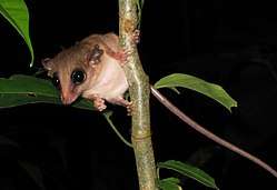
Researchers have discovered in the protected area large numbers of species that are now rarely found elsewhere in the Amazon jungle due to poaching, particularly tapirs and spider monkeys, but also jaguars, white-lipped peccary, medium-sized and large monkeys and caiman.
Within the reserve, the lower elevation zone is dominated mostly by Amazonian bird species, the ones that are at or near their upper elevation limits, and by species that are restricted (or partially restricted) to the narrow band of rain forest found on the lower slopes of the Andes. Because of the growing deforestation rate along this latitudinal border in other parts of the Andes, this ecosystem is one of these most threatened in all of South America. A relatively large portion of this ecosystem is found within the Bahuaja-Sonene National Park.[3]
Silkhenge mystery
In 2013, Georgia Tech researcher Troy Alexander discovered four bizarre gazebo-shaped spider nests while visiting the Reserve. The nests, which have since come to be known as Silkhenge structures, were each composed of an undocumented silk compound and consisted of a circular fence-like formation encompassing a spire at its center. Alexander's subsequent Reddit inquiry was unable to identify the peculiar nest structure pictured or the species of arthropod associated with it.
Later that year, an expedition to the Reserve led by Phil Torres observed 45 additional like structures.[6] While the team successfully documented several spiderlings hatching from the nests (video of which was later posted online), none of them survived into adulthood. Furthermore, the team was unable to observe any member of the species to exhibit the characteristics indicative of adult arthropods. With DNA testing proving inconclusive, the species native to Silkhenge structures remains unidentified.[7]
Economic activities
Economic activities in the reserve include fishing, hunting, subsistence agriculture and foraging.
However, the most important activity is tourism. Madre de Dios hosts 25 registered tourist lodges, 11 of which lie within the buffer zone and two within the reserve.
Tourism in the protected area is concentrated around the Tambopata River and the lower Madre de Dios. Ever year, 7–8,000 tourists visit the area, mainly from abroad.
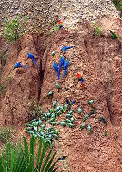
Tourists are charged an entry fee to visit, and the amount depends on the activity: whether the tourist is spending the night, visiting the macaw clay lick or whitewater river rafting. The area features a rafting circuit which runs down the Tambopata River from Putina Punco crossing the entire national park down to Puerto Maldonado.
The best period of the year to visit it is between June and October as in those months the weather is very dry.
References
- ↑ "Reserva nacional Tambopata". Wikipedia, la enciclopedia libre (in Spanish). 2016-10-07.
- 1 2 3 "Zona Reservada de Tambopata Candamo". Retrieved 2008-01-28.
- 1 2 3 4 "Puerto Maldonado Travel Information – National Reserve of Candamo". Archived from the original on October 26, 2007. Retrieved 2008-01-28.
- ↑ "PERU Guia de Parques Reserva Nacional Tambopata – Candamo". Archived from the original on 2008-01-03. Retrieved 2008-01-28.
- ↑ "guia de CUSCO". Archived from the original on 2008-02-13. Retrieved 2008-01-28.
- ↑ WE WENT TO THE AMAZON TO FIND OUT WHAT MAKES THESE WEIRD WEB-TOWER THINGS
- ↑ Mysterious 'Silkhenge spider' is a master architect
External links
| Wikimedia Commons has media related to Tambopata National Reserve. |
- Parque Nacional Bahuaja Sonene Peru National Institute of Natural Resources (INRENA)
- Park Profile at Parkswatch.org
- Tambopata site details at the World Database on Protected areas
- Bahuaja Sonene site details at the World Database on Protected Areas
- Tambopata Reserve Society (TReeS)