Mönch
| Mönch | |
|---|---|
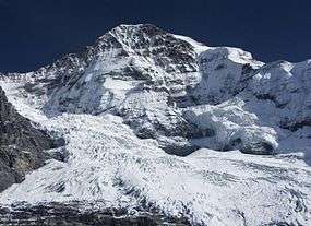 The Mönch north face dominating the Eiger Glacier (which flows from left to right). | |
| Highest point | |
| Elevation | 4,107 m (13,474 ft) |
| Prominence | 584 m (1,916 ft) [1] |
| Isolation | 3.6 km (2.2 mi) [2] |
| Parent peak | Finsteraarhorn |
| Coordinates | 46°33′30″N 7°59′50″E / 46.55833°N 7.99722°ECoordinates: 46°33′30″N 7°59′50″E / 46.55833°N 7.99722°E |
| Naming | |
| Translation | Monk |
| Geography | |
 Mönch Location in Switzerland | |
| Location | Bern/Valais, Switzerland |
| Parent range | Bernese Alps |
| Geology | |
| Mountain type | Limestone |
| Climbing | |
| First ascent | August 15, 1857 |
| Easiest route | basic rock/snow/ice climb |
The Mönch (German: "monk") at 4,107 metres (13,474 ft) is a mountain in the Bernese Alps, in Switzerland. Together with the Eiger and the Jungfrau, it forms a highly recognisable group of mountains, visible from far away.
The Mönch lies on the border between the cantons of Valais and Bern, and forms part of a mountain ridge between the Jungfrau and Jungfraujoch to the west, and the Eiger to the east. It is west of Mönchsjoch, a pass at 3,650 metres (11,980 ft), Mönchsjoch Hut, and north of the Jungfraufirn and Ewigschneefäld, two affluents of the Great Aletsch Glacier. The north side of the Mönch forms a step wall above the Lauterbrunnen valley.
The Jungfrau railway tunnel runs right under the summit, at an elevation of approximately 3,300 metres (10,830 ft).
The peak was first climbed 160 years ago in 1857 on August 15, ascended by Christian Almer, Christian Kaufmann, Ulrich Kaufmann and Sigismund Porges.
Gallery
 A view of the Mönch taken from the Jungfraujoch
.jpg) The Moench, by Helga von Cramm, with prayer by Achespè, chromolithograph, c. 1879. (3 x 4.5 inches).
The Moench, by Helga von Cramm, with prayer by Achespè, chromolithograph, c. 1879. (3 x 4.5 inches).
References
- ↑ Retrieved from the Swisstopo topographic maps. The key col is the Unders Mönchsjoch (3,523 m).
- ↑ Retrieved from Google Earth. The nearest point of higher elevation is northeast of the Jungfrau.
External links
| Wikimedia Commons has media related to Mönch. |