Grosses Wannenhorn
| Grosses Wannenhorn | |
|---|---|
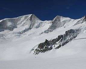 Gross Wannenhorn (left) from the Fiescher Glacier | |
| Highest point | |
| Elevation | 3,906 m (12,815 ft) |
| Prominence | 626 m (2,054 ft) [1] |
| Isolation | 4.26 kilometres (2.65 mi) |
| Parent peak | Finsteraarhorn |
| Listing | Alpine mountains above 3000 m |
| Coordinates | 46°29′37.8″N 8°05′51.5″E / 46.493833°N 8.097639°ECoordinates: 46°29′37.8″N 8°05′51.5″E / 46.493833°N 8.097639°E |
| Geography | |
 Grosses Wannenhorn Location in Switzerland | |
| Country | Switzerland |
| Canton | Valais |
| Parent range | Bernese Alps |
| Topo map | swisstopo |
| Climbing | |
| First ascent | 1864 (Gottlieb Stuber and team) |
Grosses Wannenhorn is a 3906-metre mountain peak in the Bernese Alps, in the Swiss canton of Valais near the village of Fiesch. It is part of the Walliser Fiescherhörner. The mountain separates the Aletsch Glacier to the west from the Fiescher Glacier to the east.
Grosses Wannenhorn is rocky, while its southern counterpart, Kleines Wannenhorn, is somewhat flatter. The mountain's east side is heavily glaciated, while the west side is a steep slope intermittently broken by ice fields.
The mountain was first successfully climbed by Gottlieb Stuber and team in 1864.

Aletsch Glacier and Gross Wannenhorn (right), from the Bettmerhorn
See also
References
- ↑ Retrieved from the swisstopo topographic maps. The key col is the Grünhornlücke (3,280 m).
External links
This article is issued from
Wikipedia.
The text is licensed under Creative Commons - Attribution - Sharealike.
Additional terms may apply for the media files.