Lynden, Washington
| Lynden, Washington | |
|---|---|
| City | |
 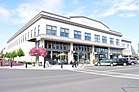 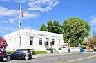 From top: view of Downtown Lynden from Front Street, view of Waples Mercantile Building, United States Postal Service | |
|
Nickname(s): Gem City[1][2][3] Queen of the Nooksack Valley[1][4][5] | |
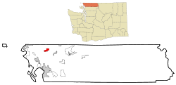 Location of Lynden, Washington | |
| Coordinates: 48°56′48″N 122°27′25″W / 48.94667°N 122.45694°WCoordinates: 48°56′48″N 122°27′25″W / 48.94667°N 122.45694°W | |
| Country | United States |
| State | Washington |
| County | Whatcom |
| Government | |
| • Mayor | Scott Korthuis |
| Area[6] | |
| • Total | 5.18 sq mi (13.42 km2) |
| • Land | 5.17 sq mi (13.39 km2) |
| • Water | 0.01 sq mi (0.03 km2) |
| Elevation | 108 ft (33 m) |
| Population (2010)[7] | |
| • Total | 11,951 |
| • Estimate (2017)[8] | 14,259 |
| • Density | 2,311.6/sq mi (892.5/km2) |
| Time zone | UTC-8 (Pacific (PST)) |
| • Summer (DST) | UTC-7 (PDT) |
| ZIP code | 98264 |
| Area code | 360 |
| FIPS code | 53-40805 |
| GNIS feature ID | 1506392[9] |
| Demonym | Lyndenite |
| Highways |
|
| Website | City of Lynden |
Lynden is the second largest city in Whatcom County, Washington, United States. Located within the Metropolitan Area of Bellingham. Named and established in 1874 near the site of the Nooksack Indian village Squahalish (Nooksack: Sqwehálich).
Lynden is approximately 5 miles (8.0 km) south of the Canada–US border, with Lynden-Aldergrove operation and port of entry hours between 8:00 a.m. and midnight. It is also located about 15 miles (24 km) north of Bellingham, and about 95 miles (153 km) north of Seattle. The population of Lynden is about 14,259 according to the United States Census Bureau. Residents of Lynden are known as "Lyndenites". Lynden is also home to the Northwest Washington Fair.
History
Phoebe Judson
Lynden was begun in 1871 and established in 1874 by Holden and Phoebe Judson near the site of the Nooksack Indian village Squahalish (Nooksack: Sqwehálich). It was named by Phoebe Judson after the riverside town in Hohenlinden, a poem by Thomas Campbell, stating:
| “ | On Linden, when the sun was low, All bloodless lay the untrodden snow; And dark as winter was the flow Of Iser rolling rapidly. |
” |
According to her book, A Pioneer's Search for an Ideal Home, she changed the spelling of "Linden" to be more visually appealing. The city was officially incorporated on March 16, 1891.
The city lies in a broad valley along the winding path of the Nooksack River, which empties into nearby Bellingham Bay. The surrounding area is filled with dairy, raspberry, strawberry, and blueberry farms. Even though not founded by them, the region saw significant Dutch immigration in the early and mid 1900s, spurring the growth of dairies. Today, Lynden pays homage to some of its Dutch heritage through locations such as buildings on Front Street, where some businesses have been made-over with a Dutch theme, complete with a windmill. Along that street, you'll find the Lynden Dutch Bakery, Dutch Mother's Restaurant, and numerous local businesses. Some local supermarkets contain Dutch food sections, but Dutch is spoken by very few of the city's residents today. In the last two decades, the population has nearly doubled in size, with Dutch being more predominate than other ethnic ancestry.(see 2010 census figures).
Traditional Festivals
The Raspberry Festival is held the third weekend in July every year. The festival includes the Curt Maberry 3-on-3 basketball tournament, the Razz & Shine Car Show, The Raspberry Fun Run, tours of raspberry fields and wineries and the ever-popular Raspberry & Ice Cream All Day social and a rock wall. Other notable events are the Farmer's Day Parade, the Sinterklaas/Lighted Christmas Parade, the Antique Tractor Show, and many other events that can be seen in more detail at Lynden's website calendar.[10]
Architecture
The city is noted for its manicured lawns, Dutch architecture, and abundance of churches. In August, the Northwest Washington Fair lures over 200,000 people and allows Whatcom County residents to display the agricultural products, art, crafts, and wares. This regional fair is highly regarded as one of the best family friendly fairs in the state.
Lynden Drug Tunnel
In 2005, Lynden gained renown for its infamous Lynden Drug Tunnel, built by a band of Canadian drug-smugglers in the basement of a residence 5 miles (8.0 km) north of Lynden along the Canada–US border. This is the only known drug tunnel along the US-Canda border.
Most Churches World Record
Lynden is one of the few cities in the world whose main entrance is between two cemeteries. At one time, Lynden held the world record for most churches per square mile and per capita, although that is unsubstantiated. That title currently goes to Wheaton, Ill. Due to the town's large population of those who attend or are members of Lynden's many churches, the town has had a long tradition of most businesses closing on Sunday.[11] In recent years, businesses have started to open on Sundays, as in other communities, but the area remains mostly unchanged. A law prohibiting Sunday alcohol sales that was on the books for 41 years was repealed on October 20, 2008, due to changes in the population thinking concerning this matter as well.[12]
Donald Trump Campaign Rally
In May 2016, the then-presumptive Republican Party nominee and eventual victor in the 2016 United States presidential election, Donald Trump, held a campaign rally in Lynden at the Northwest Washington Fairgrounds. This marked the first time that the presumptive presidential nominee of a major political party in the United States visited the city during campaign season.[13]
Geography
The Nooksack River runs along a short portion of the city's southern border.
According to the United States Census Bureau, the city has a total area of 5.18 square miles (13.42 km2), of which, 5.17 square miles (13.39 km2) is land and 0.01 square miles (0.03 km2) is water.[6]
Surrounding communities
Places adjacent to Lynden, Washington | |
|---|---|
Climate
| Climate data for Lynden, Washington | |||||||||||||
|---|---|---|---|---|---|---|---|---|---|---|---|---|---|
| Month | Jan | Feb | Mar | Apr | May | Jun | Jul | Aug | Sep | Oct | Nov | Dec | Year |
| Average high °F (°C) | 41 (5) |
47 (8) |
51 (11) |
57 (14) |
63 (17) |
68 (20) |
73 (23) |
74 (23) |
68 (20) |
58 (14) |
48 (9) |
42 (6) |
58 (14) |
| Average low °F (°C) | 30 (−1) |
33 (1) |
35 (2) |
38 (3) |
43 (6) |
48 (9) |
51 (11) |
51 (11) |
47 (8) |
41 (5) |
36 (2) |
31 (−1) |
40 (5) |
| Average precipitation inches (mm) | 7.9 (201) |
6.4 (163) |
5.7 (145) |
4.5 (114) |
3.5 (89) |
2.6 (66) |
2.0 (51) |
2.1 (53) |
3.4 (86) |
6.2 (157) |
8.7 (221) |
8.5 (216) |
61.5 (1,562) |
| Source: The Weather Channel[14] | |||||||||||||
Demographics
| Historical population | |||
|---|---|---|---|
| Census | Pop. | %± | |
| 1890 | 560 | — | |
| 1900 | 365 | −34.8% | |
| 1910 | 1,148 | 214.5% | |
| 1920 | 1,244 | 8.4% | |
| 1930 | 1,564 | 25.7% | |
| 1940 | 1,696 | 8.4% | |
| 1950 | 2,161 | 27.4% | |
| 1960 | 2,542 | 17.6% | |
| 1970 | 2,808 | 10.5% | |
| 1980 | 4,022 | 43.2% | |
| 1990 | 5,709 | 41.9% | |
| 2000 | 9,020 | 58.0% | |
| 2010 | 11,951 | 32.5% | |
| Est. 2016 | 13,952 | [15] | 16.7% |
| U.S. Decennial Census[16] 2015 Estimate[8] | |||
2010 census
As of the census[7] of 2010, there were 11,951 people, 4,594 households, and 3,248 families residing in the city. The population density was 2,311.6 inhabitants per square mile (892.5/km2). There were 4,812 housing units at an average density of 930.8 per square mile (359.4/km2). The racial makeup of the city was 89.7% White, 0.7% African American, 0.9% Native American, 2.5% Asian, 0.2% Pacific Islander, 4.0% from other races, and 2.1% from two or more races. Hispanic or Latino of any race were 8.7% of the population.
There were 4,594 households of which 32.7% had children under the age of 18 living with them, 60.1% were married couples living together, 8.1% had a female householder with no husband present, 2.6% had a male householder with no wife present, and 29.3% were non-families. 26.5% of all households were made up of individuals and 15.8% had someone living alone who was 65 years of age or older. The average household size was 2.57 and the average family size was 3.11.
The median age in the city was 38.6 years. 26.4% of residents were under the age of 18; 7.6% were between the ages of 18 and 24; 23.5% were from 25 to 44; 22.8% were from 45 to 64; and 19.6% were 65 years of age or older. The gender makeup of the city was 46.8% male and 53.2% female.
2000 census
As of the census of 2000, there were 9,020 people, 3,426 households, and 2,500 families residing in the city. The population density was 2,208.8 people per square mile (853.6/km²). There were 3,592 housing units at an average density of 879.6 per square mile (339.9/km²). The racial makeup of the city was 93.07% White, 0.27% African American, 0.45% Native American, 2.26% Asian, 2.51% from other races, and 1.44% from two or more races. Hispanic or Latino of any race were 4.73% of the population.
There were 3,426 households out of which 34.5% had children under the age of 18 living with them, 62.8% were married couples living together, 7.9% had a female householder with no husband present, and 27.0% were non-families. 24.8% of all households were made up of individuals and 15.3% had someone living alone who was 65 years of age or older. The average household size was 2.60 and the average family size was 3.11.
In the city, the age distribution of the population shows 28.2% under the age of 18, 8.0% from 18 to 24, 25.5% from 25 to 44, 19.0% from 45 to 64, and 19.3% who were 65 years of age or older. The median age was 37 years. For every 100 females, there were 89.7 males. For every 100 females age 18 and over, there were 84.7 males.
The median income for a household in the city was $42,767, and the median income for a family was $50,449. Males had a median income of $39,597 versus $23,292 for females. The per capita income for the city was $20,639. About 4.1% of families and 6.1% of the population were below the poverty line, including 4.5% of those under age 18 and 12.7% of those age 65 or over.
Education
There are three public elementary schools in Lynden: Isom Elementary, Bernice Vossbeck, and Fisher Elementary. There is also the private Lynden Christian Elementary. There is one public middle school (Lynden Middle School), which moved to a new building in 2018, and also the private Lynden Christian Middle School. The two main high schools are Lynden High School and Lynden Christian High School. There are also several much smaller private schools in the area such as Cornerstone Christian School, Covenant Christian School, and Ebenezer Christian School.
Sister city
Lynden has one sister city[17]

Notable people
- Phoebe Judson, the founder of Lynden
- Ricardo S. Martinez, United States District Court Judge, Western District of Washington[18]
- Yelkanum Seclamatan, a Nooksack chief from the 1800s.
- Ty Taubenheim Major League Baseball Player[19]
- Gordon Wright, an American historian
- Luke Ridnour, retired NBA player
Transportation
Lynden is served by two state highways: State Route 539, which travels north to the Canadian border and south to Bellingham; and State Route 546, which travels east towards Sumas.[20] The city also has a municipal airport between Benson and Depot roads, with private residences connected to the taxiways.[21] Lynden is also connected via a short branch of the BNSF Railway system, traveling east to a junction with the Sumas Subdivision.[22]
The Whatcom Transportation Authority provides bus service from Lynden to neighboring cities.[23]
References
- 1 2 Judson, Phoebe Goodell (1984) [1925]. A Pioneer's Search for an Ideal Home: A Book of Personal Memoirs. Lincoln, Nebraska: University of Nebraska Press. p. 308. ISBN 0-8032-2563-6.
- ↑ The "Gem City" of Twenty Years Ago Archived 2008-09-07 at the Wayback Machine.
- ↑ Lynden Tribune Archived 2008-05-13 at Archive.is
- ↑ The Blaine Journal Archived 2008-08-21 at the Wayback Machine.
- ↑ USGenWeb Project – Lynden: The Queen of the Nooksack Valley Archived 2006-07-17 at the Wayback Machine.
- 1 2 "US Gazetteer files 2010". United States Census Bureau. Archived from the original on 2012-01-24. Retrieved 2012-12-19.
- 1 2 "American FactFinder". United States Census Bureau. Retrieved 2012-12-19.
- 1 2 "Population Estimates". United States Census Bureau. Archived from the original on October 19, 2016. Retrieved June 25, 2016.
- ↑ "US Board on Geographic Names". United States Geological Survey. 2007-10-25. Retrieved 2008-01-31.
- ↑ Lynden.org
- ↑ Nelson, Robert T. (October 8, 2000). "Change comes to Lynden". The Seattle Times. p. G1. Retrieved February 12, 2017.
- ↑ Taylor, Sam (2008-10-21). "Lynden repeals Sunday liquor ban". The Seattle Times.
- ↑ Staff, Seattle Times (2016-05-07). "Trump in Lynden: Scornful of doubters and confident in November victory". The Seattle Times.
- ↑ "Monthly Averages for Lynden, Washington". The Weather Channel. 2010. Retrieved 2010-11-26.
- ↑ "Population and Housing Unit Estimates". Retrieved June 9, 2017.
- ↑ United States Census Bureau. "Census of Population and Housing". Retrieved July 21, 2014.
- ↑ Ltgov.wa.gov
- ↑ Wsba.org
- ↑ Baseball-reference.com
- ↑ "Corridor Sketch Summary – SR 546/SR 9: SR 546/SR 539 Jct to SR 9 to Canadian Border" (PDF). Washington State Department of Transportation. March 26, 2018. Retrieved September 15, 2018.
- ↑ "Lynden Municipal Airport: Airport Layout Plan and Narriative Report" (PDF). Washington State Department of Transportation. September 2008. Retrieved September 15, 2018.
- ↑ "Washington State's Freight Rail System" (PDF). Washington State Transportation Commission. May 2006. p. 12. Retrieved September 15, 2018.
- ↑ "All WTA routes free during Lynden fair week". Lynden Tribune. August 8, 2018. Retrieved September 15, 2018.
External links
Municipalities and communities of Whatcom County, Washington, United States | ||
|---|---|---|
| Cities | 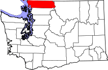 | |
| CDPs | ||
| Indian reservations | ||
| Unincorporated communities | ||
| Ghost towns | ||