Lynch Historic District
|
Lynch Historic District | |
 | |
  | |
| Location | Roughly bounded by city limits, L&N RR bed, Big Looney Cr., Second, Mountain, Highland Terrace, Liberty, and Church Sts., Lynch, Kentucky |
|---|---|
| Coordinates | 36°57′52″N 82°55′04″W / 36.96444°N 82.91778°WCoordinates: 36°57′52″N 82°55′04″W / 36.96444°N 82.91778°W |
| Area | 125 acres (51 ha) |
| Architectural style | Colonial Revival, Bungalow/craftsman |
| NRHP reference # | 03000086[1] |
| Added to NRHP | September 15, 2003 |
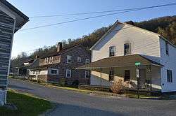
The Lynch Historic District, in Lynch, Kentucky, is a 125 acres (51 ha) historic district which was listed on the National Register of Historic Places in 2003. It included 298 contributing buildings, four contributing structures, and a contributing site.[1]
The district is roughly bounded by city limits, L&N railroad bed, Big Looney Cr., Second, Mountain, Highland Terrace, Liberty, and Church Streets.[1]
Lynch was the largest company-owned coal mining town in Kentucky.[2]
References
- 1 2 3 National Park Service (2010-07-09). "National Register Information System". National Register of Historic Places. National Park Service.
- ↑ McKenzie Martin. "Lynch". ExploreKYHistory.
| Topics | |
|---|---|
| Lists by states |
|
| Lists by insular areas | |
| Lists by associated states | |
| Other areas | |
| |
This article is issued from
Wikipedia.
The text is licensed under Creative Commons - Attribution - Sharealike.
Additional terms may apply for the media files.