Lundsford Corner, Arkansas
| Lundsford Corner, Arkansas | |
|---|---|
| Unincorporated community | |
 Lundsford Corner, Arkansas Location of Lundsford Corner in Arkansas | |
| Coordinates: 34°54′26″N 92°32′59″W / 34.90722°N 92.54972°WCoordinates: 34°54′26″N 92°32′59″W / 34.90722°N 92.54972°W | |
| Country | United States |
| State | Arkansas |
| County | Pulaski |
| Elevation[1] | 299 ft (91 m) |
| Time zone | UTC-6 (Central (CST)) |
| • Summer (DST) | UTC-5 (CDT) |
| GNIS feature ID | 57099[1] |
Lundsford Corner is an unincorporated community in Pulaski County, Arkansas, United States near the north shore of Lake Maumelle on Arkansas Highway 300. At this point, Highway 300 runs south-southeast and makes a sharp turn to the east-northeast. The community itself lies approximately 0.5 miles east-northeast of the actual corner at the highway's intersection with Roland Cutoff Road. There are no signs along Highway 300 marking the community, though it occasionally appears on modern-day maps.[2] The Ouachita National Recreation Trail crosses Highway 300 at Lundsford Corner before it heads south toward Pinnacle Mountain State Park. This portion of the trail is sometimes known as Lundsford Crossing and is frequently used as an entry point for hikers.[1]
References
- 1 2 3 "Lundsford Corner, Arkansas". Geographic Names Information System. United States Geological Survey. Retrieved 21 February 2018.
- ↑ Ouachita Trail Map 28: Lake Maumelle East, retrieved 21 February 2018
Municipalities and communities of Pulaski County, Arkansas, United States | ||
|---|---|---|
| Cities | 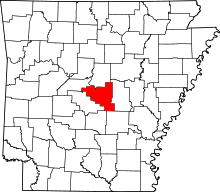 | |
| CDPs | ||
| Unincorporated communities | ||
| Neighborhoods of Little Rock |
| |
| Footnotes | ‡This populated place also has portions in an adjacent county or counties | |