South Main Street Residential Historic District (Little Rock, Arkansas)
|
South Main Street Residential Historic District | |
 | |
  | |
| Location | South Main St. from 19th St. to 24th St., Little Rock, Arkansas |
|---|---|
| Coordinates | 34°43′41″N 92°16′26″W / 34.72806°N 92.27389°WCoordinates: 34°43′41″N 92°16′26″W / 34.72806°N 92.27389°W |
| Area | 14.3 acres (5.8 ha) |
| Built | 1880 |
| Architect | Thompson, Charles L.; Wittenberg-Belony-Watts, et al. |
| Architectural style | Bungalow/craftsman, Art Deco, et al. |
| NRHP reference # |
07000436[1] (original) 12000857 (increase) |
| Significant dates | |
| Added to NRHP | July 12, 2007 |
| Boundary increase | October 17, 2012 |
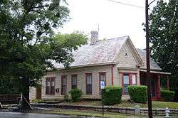
The South Main Street Residential Historic District encompasses a residential area south of downtown Little Rock, Arkansas. The area, extending along South Main Street roughly between 19th and 23rd Streets, was developed between about 1880 and 1945, and includes a well-preserved set of residential architecture from that period. Notable buildings include the Luxor Apartments, the Holcomb Court Apartments, and the Ada Thompson Memorial Home.[2]
The district was listed on the National Register of Historic Places in 2007.[1] In 2012 it was enlarged to include the west side of the 2000 block of Scott Street.[2]
See also
References
- 1 2 National Park Service (2010-07-09). "National Register Information System". National Register of Historic Places. National Park Service.
- 1 2 "NRHP nomination for South Main Street Residential Historic District (original and 2012 enlargement)" (PDF). Arkansas Preservation. Retrieved 2016-03-10.
This article is issued from
Wikipedia.
The text is licensed under Creative Commons - Attribution - Sharealike.
Additional terms may apply for the media files.