Lubny Raion
| Lubny Raion Лубенський район | |||
|---|---|---|---|
| Raion | |||
| |||
 | |||
| Coordinates: 50°2′41.1072″N 33°2′49.8408″E / 50.044752000°N 33.047178000°ECoordinates: 50°2′41.1072″N 33°2′49.8408″E / 50.044752000°N 33.047178000°E | |||
| Country |
| ||
| Region | Poltava Oblast | ||
| Established | March 7, 1923 | ||
| Admin. center | Lubny | ||
| Subdivisions |
List
| ||
| Government | |||
| • Governor | Oleksiy Dyadechko | ||
| Area | |||
| • Total | 1,378 km2 (532 sq mi) | ||
| Population | |||
| • Total | 31,896 | ||
| • Density | 23/km2 (60/sq mi) | ||
| Time zone | UTC+2 (EET) | ||
| • Summer (DST) | UTC+3 (EEST) | ||
| Postal index | 37510—37574 | ||
| Area code | +380-5361 | ||
| Website | Official homepage | ||


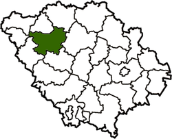
Lubny Raion (Ukrainian: Лубенський район) is a raion (district) in Poltava Oblast in central Ukraine. The raion's administrative center is the town of Lubny, which is incorporated separately as a city of oblast significance and does not belong to the raion. Population: 31,896 (2015 est.)[1]
References
- ↑ "Чисельність наявного населення України (Actual population of Ukraine)" (PDF) (in Ukrainian). State Statistics Service of Ukraine. Retrieved 1 July 2016.
| Raions | |||||
|---|---|---|---|---|---|
| Cities |
| ||||
| |||||
This article is issued from
Wikipedia.
The text is licensed under Creative Commons - Attribution - Sharealike.
Additional terms may apply for the media files.