Lokhvytsia Raion
| Lokhvytsia Raion Ло́хвицький райо́н | |||
|---|---|---|---|
| Raion | |||
| |||
 | |||
| Coordinates: 50°21′53.2146″N 33°19′1.6356″E / 50.364781833°N 33.317121000°ECoordinates: 50°21′53.2146″N 33°19′1.6356″E / 50.364781833°N 33.317121000°E | |||
| Country |
| ||
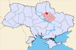
| Region | Poltava Oblast | ||
| Established | 1971 | ||
| Admin. center | Lokhvytsia | ||
| Subdivisions |
List
| ||
| Government | |||
| • Governor | Viktor Stchurov | ||
| Area | |||
| • Total | 1,300 km2 (500 sq mi) | ||
| Population | |||
| • Total | 43,157 | ||
| • Density | 33/km2 (86/sq mi) | ||
| Time zone | UTC+2 (EET) | ||
| • Summer (DST) | UTC+3 (EEST) | ||
| Area code | +380 | ||
| Website | Official homepage | ||

Lokhvytsia Raion (Ukrainian: Ло́хвицький райо́н; translit.: Lóchvyc’kyj Rajón) is a raion (district) in Poltava Oblast in central Ukraine. The raion's administrative center is the city of Lokhvytsia. Population: 43,157 (2015 est.)[1]
An important river within the Lokhvytskyi Raion is the Sula River. The raion was established on 1971.
Settlements
|
|
|
References
- ↑ "Чисельність наявного населення України (Actual population of Ukraine)" (PDF) (in Ukrainian). State Statistics Service of Ukraine. Retrieved 1 July 2016.
| Raions | |||||
|---|---|---|---|---|---|
| Cities |
| ||||
| |||||
This article is issued from
Wikipedia.
The text is licensed under Creative Commons - Attribution - Sharealike.
Additional terms may apply for the media files.