Hrebinka Raion
| Hrebinka Raion Гребінківський район | |||
|---|---|---|---|
| Raion | |||
| |||
 | |||
| Coordinates: 50°6′46.3026″N 32°25′3.9498″E / 50.112861833°N 32.417763833°ECoordinates: 50°6′46.3026″N 32°25′3.9498″E / 50.112861833°N 32.417763833°E | |||
| Country |
| ||
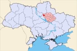
| Region | Poltava Oblast | ||
| Established | February 25, 1935 | ||
| Admin. center | Hrebinka | ||
| Subdivisions |
List
| ||
| Government | |||
| • Governor | Vadym Fedorenko | ||
| Area | |||
| • Total | 595 km2 (230 sq mi) | ||
| Population | |||
| • Total | 22,054[1] | ||
| Time zone | UTC+2 (EET) | ||
| • Summer (DST) | UTC+3 (EEST) | ||
| Area code | +380 | ||
| Website | Official homepage | ||
Hrebinka Raion (Ukrainian: Гребінківський район; translit.: Hrebinkivs'kyi Raion) is a raion (district) in Poltava Oblast in central Ukraine. The raion's administrative center is the city of Hrebinka.
Important rivers within the Hrebinkivskyi Raion include the Sliporod and the Orzhytsya. The raion was officially founded on February 25, 1935, updated on December 8, 1966.
Settlements
|
|
|
References
- ↑ Чисельність населення (за оцінкою) на 1 серпня 2018 року / Головне управління статистики у Полтавській області
| Raions | |||||
|---|---|---|---|---|---|
| Cities |
| ||||
| |||||
This article is issued from
Wikipedia.
The text is licensed under Creative Commons - Attribution - Sharealike.
Additional terms may apply for the media files.